Atri geodata
Atri (Abruzzo) is a seat of a third-order administrative division; located in Italy in Europe/Rome (GMT+2) time zone. With population of 5,854 people, there are 1677 cities with bigger population in this country. Compared to other cities in Italy, 65.8% of cities are located further ↑North; 78.1% of cities are located further ←West and 71.9% of cities have lower elevation than Atri. Note1


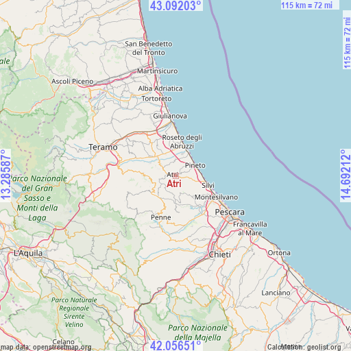
Atri GPS coordinates[2]
42° 34' 35.112" North, 13° 59' 20.364" East
| Map corner | latitude | longitude |
|---|---|---|
| Upper-left | 43.09203°, | 13.28587° |
| Center: | 42.57642°, | 13.98899° |
| Lower-right: | 42.05651°, | 14.69212° |
| Map W x H: | 115.1×115.1 km | = 71.5×71.5mi |
| max Lat: | 47.04031° ⇑65.8% North |
| Atri: | 42.57642° |
| min Lat: | ⇓34.2% South 35.50142° |
| min Long | Atri | max Long |
| 6.69888° | 13.98899° | 18.48682° |
| W 78.1%⇐ | ⇒21.9% E |
Elevation
Elevation of Atri is 414 m = 1358 ft, and this is 107.3 m = 352 ft above average elevation for this country.
| Max E: |
2085 m = 6841 ft | 28.1% |
| Atri | 414 m 1358 ft | |
| Avg. | 306.7 m = 1006 ft | |
Min E: |
-4 m = -13 ft | 71.9% |
See also: Italy elevation on elevation.city.
Geographical zone
Atri is located in North temperate zone (between Tropic of Cancer and the Arctic Circle). Distance of this Northern Tropic circle is 2128.1 km =1322.3 mi to South.| Distance of | km | miles | from Atri |
|---|---|---|---|
| North Pole | 5273 | 3276.5 | to North |
| Arctic Circle | 2667.1 | 1657.3 | to North |
| Tropic Cancer | 2128.1 | 1322.3 | to South |
| Equator | 4734.1 | 2941.6 | to South |


Nearby cities:
15 places around Atri: (largest is in red/bold)
• Borgo Santa Maria Immacolata
6.1 km =3.8 mi,  49°
49°
• Casoli
4.6 km =2.9 mi,  349°
349°
• Castilenti
7.6 km =4.7 mi,  230°
230°
• Elice
6.1 km =3.8 mi,  194°
194°
• Fontanelle
6.9 km =4.3 mi,  311°
311°
• Mutignano
4 km =2.5 mi,  71°
71°
• Pagliare
8.1 km =5 mi,  337°
337°
• Pianacce
8.4 km =5.2 mi,  105°
105°
• Pianura Vomano
8.5 km =5.3 mi, 314°
• Pineto
7.3 km =4.5 mi,  60°
60°
• San Giovanni
8.6 km =5.3 mi,  358°
358°
• Santa Lucia
8.1 km =5 mi, 345°
• Santa Maria a Valle
7.6 km =4.7 mi,  76°
76°
• Silvi Paese
8.2 km =5.1 mi,  100°
100°
• Zona P.E.E.P.
6.5 km =4 mi, 59°
Sources, notices
• [Note1] Compared only with cities in Italy existing in our database
• [Src1] Map data: © OpenStreetMap contributors (CC-BY-SA)
• [Src2] Other city data from geonames.org with taken over terms of usage.
• [Src3] Geographical zone / Annual Mean Temperature by Robert A. Rohde @ Wikipedia
