Mutignano geodata
Mutignano (Abruzzo) is a populated place; located in Italy in Europe/Rome (GMT+2) time zone. With population of 626 people, there are 8795 cities with bigger population in this country. Compared to other cities in Italy, 65.8% of cities are located further ↑North; 78.4% of cities are located further ←West and 59.4% of cities have lower elevation than Mutignano. Note1


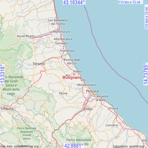
Mutignano GPS coordinates[2]
42° 35' 16.512" North, 14° 2' 4.992" East
| Map corner | latitude | longitude |
|---|---|---|
| Upper-left | 43.10344°, | 13.3316° |
| Center: | 42.58792°, | 14.03472° |
| Lower-right: | 42.0681°, | 14.73785° |
| Map W x H: | 115.1×115.1 km | = 71.5×71.5mi |
| max Lat: | 47.04031° ⇑65.8% North |
| Mutignano: | 42.58792° |
| min Lat: | ⇓34.2% South 35.50142° |
| min Long | Mutignano | max Long |
| 6.69888° | 14.03472° | 18.48682° |
| W 78.4%⇐ | ⇒21.6% E |
Elevation
Elevation of Mutignano is 295 m = 968 ft, and this is 11.7 m = 38 ft below average elevation for this country.
| Max E: |
2085 m = 6841 ft | 40.6% |
| Avg. | 306.7 m = 1006 ft | |
| Mutignano | 295 m = 968 ft | |
Min E: |
-4 m = -13 ft | 59.4% |
See also: Italy elevation on elevation.city.
Geographical zone
Mutignano is located in North temperate zone (between Tropic of Cancer and the Arctic Circle). Distance of this Northern Tropic circle is 2129.4 km =1323.1 mi to South.| Distance of | km | miles | from Mutignano |
|---|---|---|---|
| North Pole | 5271.7 | 3275.7 | to North |
| Arctic Circle | 2665.8 | 1656.5 | to North |
| Tropic Cancer | 2129.4 | 1323.1 | to South |
| Equator | 4735.3 | 2942.4 | to South |


Nearby cities:
15 places around Mutignano: (largest is in red/bold)
• Atri
4 km =2.5 mi,  251°
251°
• Borgo Santa Maria Immacolata
2.8 km =1.7 mi,  18°
18°
• Casoli
5.6 km =3.5 mi,  305°
305°
• Città Sant'Angelo
8.7 km =5.4 mi,  165°
165°
• Elice
8.9 km =5.5 mi,  215°
215°
• Pagliare
9.2 km =5.7 mi, 312°
• Pianacce
5.6 km =3.5 mi,  129°
129°
• Pineto
3.5 km =2.2 mi,  48°
48°
• San Giovanni
8.4 km =5.2 mi,  331°
331°
• Santa Lucia
8.7 km =5.4 mi,  318°
318°
• Santa Maria a Valle
3.7 km =2.3 mi,  81°
81°
• Scerne
6.6 km =4.1 mi,  2°
2°
• Silvi
8 km =5 mi,  121°
121°
• Silvi Paese
5.1 km =3.2 mi, 122°
• Zona P.E.E.P.
2.8 km =1.7 mi,  41°
41°
Sources, notices
• [Note1] Compared only with cities in Italy existing in our database
• [Src1] Map data: © OpenStreetMap contributors (CC-BY-SA)
• [Src2] Other city data from geonames.org with taken over terms of usage.
• [Src3] Geographical zone / Annual Mean Temperature by Robert A. Rohde @ Wikipedia
