Panicarola geodata
Panicarola (Umbria) is a populated place; located in Italy in Europe/Rome (GMT+2) time zone. With population of 723 people, there are 8132 cities with bigger population in this country. Compared to other cities in Italy, 62.8% of cities are located further ↑North; 57.1% of cities are located further ←West and 55.4% of cities have lower elevation than Panicarola. Note1
Administrative division(s):
- Level 1: Umbria
- Level 2: Provincia di Perugia
- Level 3: Castiglione del Lago


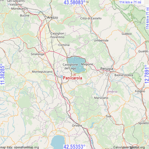
Panicarola GPS coordinates[2]
43° 4' 9.588" North, 12° 5' 9.492" East
| Map corner | latitude | longitude |
|---|---|---|
| Upper-left | 43.58083°, | 11.38285° |
| Center: | 43.06933°, | 12.08597° |
| Lower-right: | 42.55353°, | 12.7891° |
| Map W x H: | 114.2×114.2 km | = 71×71mi |
| max Lat: | 47.04031° ⇑62.8% North |
| Panicarola: | 43.06933° |
| min Lat: | ⇓37.2% South 35.50142° |
| min Long | Panicarola | max Long |
| 6.69888° | 12.08597° | 18.48682° |
| W 57.1%⇐ | ⇒42.9% E |
Elevation
Elevation of Panicarola is 268 m = 879 ft, and this is 38.7 m = 127 ft below average elevation for this country.
| Max E: |
2085 m = 6841 ft | 44.6% |
| Avg. | 306.7 m = 1006 ft | |
| Panicarola | 268 m = 879 ft | |
Min E: |
-4 m = -13 ft | 55.4% |
See also: Italy elevation on elevation.city.
Geographical zone
Panicarola is located in North temperate zone (between Tropic of Cancer and the Arctic Circle). Distance of this Northern Tropic circle is 2182.9 km =1356.4 mi to South.| Distance of | km | miles | from Panicarola |
|---|---|---|---|
| North Pole | 5218.2 | 3242.4 | to North |
| Arctic Circle | 2612.3 | 1623.2 | to North |
| Tropic Cancer | 2182.9 | 1356.4 | to South |
| Equator | 4788.9 | 2975.7 | to South |


Nearby cities:
15 places around Panicarola: (largest is in red/bold)
• Castiglione del Lago
7.2 km =4.5 mi,  328°
328°
• Fontignano
10 km =6.2 mi,  120°
120°
• Macchie
1.5 km =0.9 mi,  228°
228°
• Moiano
8.2 km =5.1 mi,  221°
221°
• Mugnano
11 km =6.8 mi,  98°
98°
• Paciano
5.4 km =3.4 mi,  195°
195°
• Panicale
4.7 km =2.9 mi,  166°
166°
• Piegaro
11.5 km =7.1 mi,  180°
180°
• Po' Bandino
12 km =7.5 mi, 231°
• Pucciarelli
3.6 km =2.2 mi,  312°
312°
• San Fatucchio
2.9 km =1.8 mi,  286°
286°
• San Feliciano
8.5 km =5.3 mi,  50°
50°
• San Savino
9.7 km =6 mi,  63°
63°
• Sant'Arcangelo
6.2 km =3.9 mi,  74°
74°
• Tavernelle
8.8 km =5.5 mi,  146°
146°
Sources, notices
• [Note1] Compared only with cities in Italy existing in our database
• [Src1] Map data: © OpenStreetMap contributors (CC-BY-SA)
• [Src2] Other city data from geonames.org with taken over terms of usage.
• [Src3] Geographical zone / Annual Mean Temperature by Robert A. Rohde @ Wikipedia
