Castellammare di Stabia geodata
Castellammare di Stabia (Campania) is a seat of a third-order administrative division; located in Italy in Europe/Rome (GMT+2) time zone. With population of 65,730 people, there are 78 cities with bigger population in this country. Compared to other cities in Italy, 82.4% of cities are located further ↑North; 82.5% of cities are located further ←West and 89.6% of cities have higher elevation than Castellammare di Stabia. Note1
Current local time in Castellammare di Stabia:
11:29 PM, WednesdayDifference from your time zone: hours


Castellammare di Stabia GPS coordinates[2]
40° 42' 7.596" North, 14° 29' 12.66" East
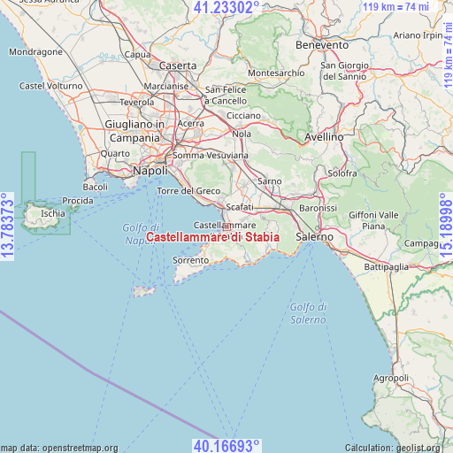
| Map corner | latitude | longitude |
|---|---|---|
| Upper-left | 41.23302°, | 13.78373° |
| Center: | 40.70211°, | 14.48685° |
| Lower-right: | 40.16693°, | 15.18998° |
| Map W x H: | 118.5×118.5 km | = 73.6×73.6mi |
| max Lat: | 47.04031° ⇑82.4% North |
| Castellammare di Stabia: | 40.70211° |
| min Lat: | ⇓17.6% South 35.50142° |
| min Long | Castellammare d | max Long |
| 6.69888° | 14.48685° | 18.48682° |
| W 82.5%⇐ | ⇒17.5% E |
Elevation
Elevation of Castellammare di Stabia is 19 m = 62 ft, and this is 287.7 m = 944 ft below average elevation for this country.
| Max E: |
2085 m = 6841 ft | 89.6% |
| Avg. | 306.7 m = 1006 ft | |
| Castellammare di Stabia | 19 m = 62 ft | |
Min E: |
-4 m = -13 ft | 10.4% |
See also: Castellammare di Stabia elevation on elevation.city.
Geographical zone
Castellammare di Stabia is located in North temperate zone (between Tropic of Cancer and the Arctic Circle). Distance of this Northern Tropic circle is 1919.7 km =1192.8 mi to South.| Distance of | km | miles | from Castellammare di Stabia |
|---|---|---|---|
| North Pole | 5481.4 | 3406 | to North |
| Arctic Circle | 2875.5 | 1786.8 | to North |
| Tropic Cancer | 1919.7 | 1192.8 | to South |
| Equator | 4525.7 | 2812.1 | to South |


Nearby cities:
15 places around Castellammare di Stabia: (largest is in red/bold)
• Calvanese
4.4 km =2.7 mi,  33°
33°
• Casola di Napoli
3.7 km =2.3 mi,  97°
97°
• Franche
4.5 km =2.8 mi,  139°
139°
• Gragnano
3.2 km =2 mi,  117°
117°
• Lettere
4.9 km =3 mi,  86°
86°
• Moiano
5.9 km =3.7 mi,  197°
197°
• Patierno
5.7 km =3.5 mi,  211°
211°
• Piazza Roma
4.7 km =2.9 mi, 87°
• Piazza-Tralia-Pendolo
3.5 km =2.2 mi,  154°
154°
• Pimonte
3.7 km =2.3 mi, 148°
• Pompei
4.9 km =3 mi,  9°
9°
• Sant'Antonio Abate
5 km =3.1 mi,  64°
64°
• Santa Maria La Carità
2.5 km =1.6 mi,  51°
51°
• Torre Annunziata
6.4 km =4 mi,  333°
333°
• Vico Equense
6.5 km =4 mi,  223°
223°
Sources, notices
• [Note1] Compared only with cities in Italy existing in our database
• [Src1] Map data: © OpenStreetMap contributors (CC-BY-SA)
• [Src2] Other city data from geonames.org with taken over terms of usage.
• [Src3] Geographical zone / Annual Mean Temperature by Robert A. Rohde @ Wikipedia
