Calvanese geodata
Calvanese (Campania) is a populated place; located in Italy in Europe/Rome (GMT+2) time zone. With population of 747 people, there are 7973 cities with bigger population in this country. Compared to other cities in Italy, 82.1% of cities are located further ↑North; 82.8% of cities are located further ←West and 94.8% of cities have higher elevation than Calvanese. Note1


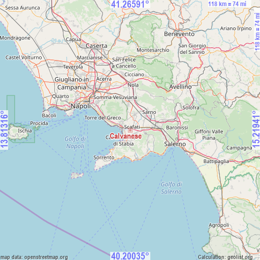
Calvanese GPS coordinates[2]
40° 44' 6.936" North, 14° 30' 58.608" East
| Map corner | latitude | longitude |
|---|---|---|
| Upper-left | 41.26591°, | 13.81316° |
| Center: | 40.73526°, | 14.51628° |
| Lower-right: | 40.20035°, | 15.21941° |
| Map W x H: | 118.5×118.5 km | = 73.6×73.6mi |
| max Lat: | 47.04031° ⇑82.1% North |
| Calvanese: | 40.73526° |
| min Lat: | ⇓17.9% South 35.50142° |
| min Long | Calvanese | max Long |
| 6.69888° | 14.51628° | 18.48682° |
| W 82.8%⇐ | ⇒17.2% E |
Elevation
Elevation of Calvanese is 9 m = 30 ft, and this is 297.7 m = 977 ft below average elevation for this country.
| Max E: |
2085 m = 6841 ft | 94.8% |
| Avg. | 306.7 m = 1006 ft | |
| Calvanese | 9 m = 30 ft | |
Min E: |
-4 m = -13 ft | 5.2% |
See also: Italy elevation on elevation.city.
Geographical zone
Calvanese is located in North temperate zone (between Tropic of Cancer and the Arctic Circle). Distance of this Northern Tropic circle is 1923.4 km =1195.1 mi to South.| Distance of | km | miles | from Calvanese |
|---|---|---|---|
| North Pole | 5477.7 | 3403.7 | to North |
| Arctic Circle | 2871.8 | 1784.5 | to North |
| Tropic Cancer | 1923.4 | 1195.1 | to South |
| Equator | 4529.3 | 2814.4 | to South |


Nearby cities:
15 places around Calvanese: (largest is in red/bold)
• Angri
4.6 km =2.9 mi,  85°
85°
• Boscoreale
5.1 km =3.2 mi,  324°
324°
• Boscotrecase
6.2 km =3.9 mi,  312°
312°
• Casola di Napoli
4.3 km =2.7 mi,  164°
164°
• Castellammare di Stabia
4.4 km =2.7 mi,  213°
213°
• Corbara
6.5 km =4 mi,  102°
102°
• Gragnano
5.1 km =3.2 mi,  176°
176°
• Lettere
4.1 km =2.5 mi,  144°
144°
• Piazza Roma
4.1 km =2.5 mi,  146°
146°
• Pompei
2 km =1.2 mi, 305°
• San Lorenzo
6.5 km =4 mi,  71°
71°
• Sant'Antonio Abate
2.5 km =1.6 mi,  127°
127°
• Santa Maria La Carità
2.2 km =1.4 mi,  194°
194°
• Scafati
3.3 km =2.1 mi,  32°
32°
• Torre Annunziata
5.7 km =3.5 mi,  290°
290°
Sources, notices
• [Note1] Compared only with cities in Italy existing in our database
• [Src1] Map data: © OpenStreetMap contributors (CC-BY-SA)
• [Src2] Other city data from geonames.org with taken over terms of usage.
• [Src3] Geographical zone / Annual Mean Temperature by Robert A. Rohde @ Wikipedia
