Gragnano geodata
Gragnano (Campania) is a seat of a third-order administrative division; located in Italy in Europe/Rome (GMT+2) time zone. With population of 29,082 people, there are 281 cities with bigger population in this country. Compared to other cities in Italy, 82.5% of cities are located further ↑North; 82.8% of cities are located further ←West and 65.6% of cities have higher elevation than Gragnano. Note1


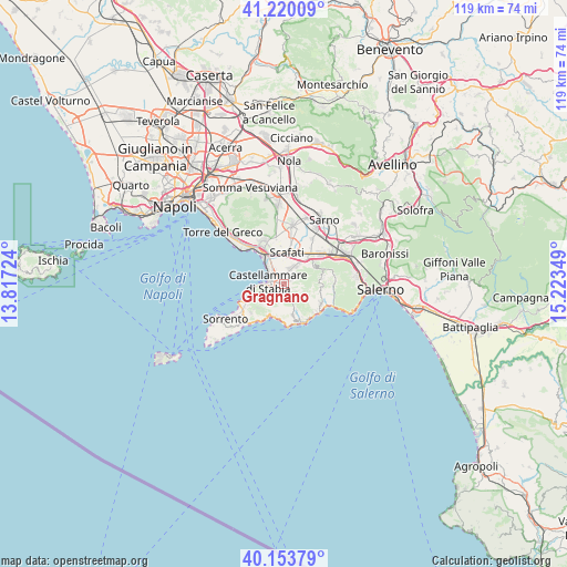
Gragnano GPS coordinates[2]
40° 41' 20.652" North, 14° 31' 13.296" East
| Map corner | latitude | longitude |
|---|---|---|
| Upper-left | 41.22009°, | 13.81724° |
| Center: | 40.68907°, | 14.52036° |
| Lower-right: | 40.15379°, | 15.22349° |
| Map W x H: | 118.6×118.6 km | = 73.7×73.7mi |
| max Lat: | 47.04031° ⇑82.5% North |
| Gragnano: | 40.68907° |
| min Lat: | ⇓17.5% South 35.50142° |
| min Long | Gragnano | max Long |
| 6.69888° | 14.52036° | 18.48682° |
| W 82.8%⇐ | ⇒17.2% E |
Elevation
Elevation of Gragnano is 124 m = 407 ft, and this is 182.7 m = 599 ft below average elevation for this country.
| Max E: |
2085 m = 6841 ft | 65.6% |
| Avg. | 306.7 m = 1006 ft | |
| Gragnano | 124 m = 407 ft | |
Min E: |
-4 m = -13 ft | 34.4% |
See also: Italy elevation on elevation.city.
Geographical zone
Gragnano is located in North temperate zone (between Tropic of Cancer and the Arctic Circle). Distance of this Northern Tropic circle is 1918.3 km =1192 mi to South.| Distance of | km | miles | from Gragnano |
|---|---|---|---|
| North Pole | 5482.9 | 3406.9 | to North |
| Arctic Circle | 2877 | 1787.7 | to North |
| Tropic Cancer | 1918.3 | 1192 | to South |
| Equator | 4524.2 | 2811.2 | to South |


Nearby cities:
15 places around Gragnano: (largest is in red/bold)
• Agerola
5.9 km =3.7 mi,  164°
164°
• Calvanese
5.1 km =3.2 mi,  356°
356°
• Casola di Napoli
1.3 km =0.8 mi,  40°
40°
• Castellammare di Stabia
3.2 km =2 mi,  297°
297°
• Franche
1.9 km =1.2 mi,  177°
177°
• Lettere
2.7 km =1.7 mi,  49°
49°
• Moiano
6.2 km =3.9 mi,  227°
227°
• Montepertuso
6.7 km =4.2 mi,  200°
200°
• Pianillo
6.6 km =4.1 mi, 158°
• Piazza Roma
2.6 km =1.6 mi, 48°
• Piazza-Tralia-Pendolo
2.2 km =1.4 mi,  217°
217°
• Pimonte
1.9 km =1.2 mi,  207°
207°
• Pompei
6.6 km =4.1 mi,  342°
342°
• Sant'Antonio Abate
4 km =2.5 mi,  24°
24°
• Santa Maria La Carità
3.1 km =1.9 mi, 343°
Sources, notices
• [Note1] Compared only with cities in Italy existing in our database
• [Src1] Map data: © OpenStreetMap contributors (CC-BY-SA)
• [Src2] Other city data from geonames.org with taken over terms of usage.
• [Src3] Geographical zone / Annual Mean Temperature by Robert A. Rohde @ Wikipedia
