Casarile geodata
Casarile (Lombardy) is a seat of a third-order administrative division; located in Italy in Europe/Rome (GMT+2) time zone. With population of 3,807 people, there are 2502 cities with bigger population in this country. Compared to other cities in Italy, 67.9% of cities are located further ↓South; 79.6% of cities are located further →East and 70.2% of cities have higher elevation than Casarile. Note1
Administrative division(s):
- Level 1: Lombardy
- Level 2: Città metropolitana di Milano
- Level 3: Casarile


Casarile GPS coordinates[2]
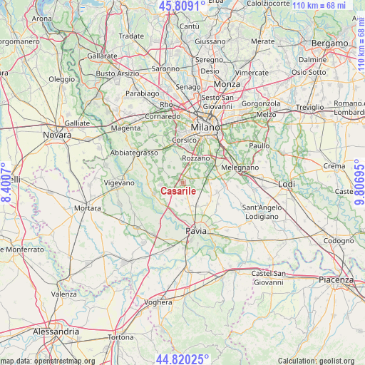
45° 19' 0.588" North, 9° 6' 13.788" East
| Map corner | latitude | longitude |
|---|---|---|
| Upper-left | 45.8091°, | 8.4007° |
| Center: | 45.31683°, | 9.10383° |
| Lower-right: | 44.82025°, | 9.80695° |
| Map W x H: | 109.9×109.9 km | = 68.3×68.3mi |
| max Lat: | 47.04031° ⇑32.1% North |
| Casarile: | 45.31683° |
| min Lat: | ⇓67.9% South 35.50142° |
| min Long | Casarile | max Long |
| 6.69888° | 9.10383° | 18.48682° |
| W 20.4%⇐ | ⇒79.6% E |
Elevation
Elevation of Casarile is 96 m = 315 ft, and this is 210.7 m = 691 ft below average elevation for this country.
| Max E: |
2085 m = 6841 ft | 70.2% |
| Avg. | 306.7 m = 1006 ft | |
| Casarile | 96 m = 315 ft | |
Min E: |
-4 m = -13 ft | 29.8% |
See also: Italy elevation on elevation.city.
Geographical zone
Casarile is located in North temperate zone (between Tropic of Cancer and the Arctic Circle). Distance of this North polar circle is 2362.4 km =1467.9 mi to North.| Distance of | km | miles | from Casarile |
|---|---|---|---|
| North Pole | 4968.3 | 3087.2 | to North |
| Arctic Circle | 2362.4 | 1467.9 | to North |
| Tropic Cancer | 2432.8 | 1511.7 | to South |
| Equator | 5038.8 | 3131 | to South |


Nearby cities:
15 places around Casarile: (largest is in red/bold)
• Badile
4.2 km =2.6 mi,  25°
25°
• Battuda
5.1 km =3.2 mi,  203°
203°
• Binasco
1.7 km =1.1 mi,  334°
334°
• Giovenzano
4.9 km =3 mi,  168°
168°
• Giussago
4.6 km =2.9 mi,  142°
142°
• Lacchiarella
2.7 km =1.7 mi,  75°
75°
• Mairano
5.3 km =3.3 mi, 329°
• Moncucco
5.1 km =3.2 mi,  261°
261°
• Pasturago
2.4 km =1.5 mi,  298°
298°
• Rognano
3.3 km =2.1 mi, 198°
• Santa Corinna
2.9 km =1.8 mi,  335°
335°
• Turago Bordone
5.7 km =3.5 mi,  117°
117°
• Vellezzo Bellini
5.3 km =3.3 mi,  182°
182°
• Vernate
3.4 km =2.1 mi,  268°
268°
• Zibido San Giacomo
4.9 km =3 mi,  6°
6°
Sources, notices
• [Note1] Compared only with cities in Italy existing in our database
• [Src1] Map data: © OpenStreetMap contributors (CC-BY-SA)
• [Src2] Other city data from geonames.org with taken over terms of usage.
• [Src3] Geographical zone / Annual Mean Temperature by Robert A. Rohde @ Wikipedia
