Giussago geodata
Giussago (Lombardy) is a seat of a third-order administrative division; located in Italy in Europe/Rome (GMT+2) time zone. With population of 1,427 people, there are 5299 cities with bigger population in this country. Compared to other cities in Italy, 67% of cities are located further ↓South; 79% of cities are located further →East and 71.5% of cities have higher elevation than Giussago. Note1


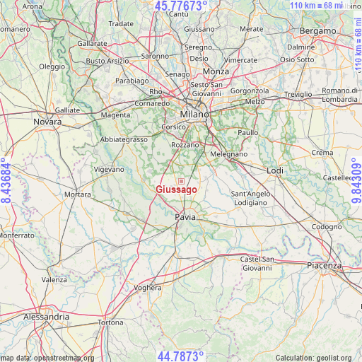
Giussago GPS coordinates[2]
45° 17' 3.012" North, 9° 8' 23.856" East
| Map corner | latitude | longitude |
|---|---|---|
| Upper-left | 45.77673°, | 8.43684° |
| Center: | 45.28417°, | 9.13996° |
| Lower-right: | 44.7873°, | 9.84309° |
| Map W x H: | 110×110 km | = 68.4×68.4mi |
| max Lat: | 47.04031° ⇑33% North |
| Giussago: | 45.28417° |
| min Lat: | ⇓67% South 35.50142° |
| min Long | Giussago | max Long |
| 6.69888° | 9.13996° | 18.48682° |
| W 21%⇐ | ⇒79% E |
Elevation
Elevation of Giussago is 90 m = 295 ft, and this is 216.7 m = 711 ft below average elevation for this country.
| Max E: |
2085 m = 6841 ft | 71.5% |
| Avg. | 306.7 m = 1006 ft | |
| Giussago | 90 m = 295 ft | |
Min E: |
-4 m = -13 ft | 28.5% |
See also: Italy elevation on elevation.city.
Geographical zone
Giussago is located in North temperate zone (between Tropic of Cancer and the Arctic Circle). Distance of this North polar circle is 2366 km =1470.2 mi to North.| Distance of | km | miles | from Giussago |
|---|---|---|---|
| North Pole | 4971.9 | 3089.4 | to North |
| Arctic Circle | 2366 | 1470.2 | to North |
| Tropic Cancer | 2429.2 | 1509.4 | to South |
| Equator | 5035.1 | 3128.7 | to South |


Nearby cities:
15 places around Giussago: (largest is in red/bold)
• Battuda
5 km =3.1 mi,  257°
257°
• Borgarello
4.8 km =3 mi,  179°
179°
• Casarile
4.6 km =2.9 mi,  322°
322°
• Certosa di Pavia
3.4 km =2.1 mi,  189°
189°
• Giovenzano
2.2 km =1.4 mi,  236°
236°
• Gualdrasco
5 km =3.1 mi,  94°
94°
• Guinzano
3.4 km =2.1 mi,  154°
154°
• Lacchiarella
4.3 km =2.7 mi,  357°
357°
• Marcignago
5.9 km =3.7 mi,  233°
233°
• Rognano
3.9 km =2.4 mi,  277°
277°
• Torre del Mangano
3.6 km =2.2 mi, 191°
• Torriano
3 km =1.9 mi,  211°
211°
• Turago Bordone
2.4 km =1.5 mi,  65°
65°
• Vellezzo Bellini
3.5 km =2.2 mi, 241°
• Zeccone
5.6 km =3.5 mi,  121°
121°
Sources, notices
• [Note1] Compared only with cities in Italy existing in our database
• [Src1] Map data: © OpenStreetMap contributors (CC-BY-SA)
• [Src2] Other city data from geonames.org with taken over terms of usage.
• [Src3] Geographical zone / Annual Mean Temperature by Robert A. Rohde @ Wikipedia
