Casaloldo geodata
Casaloldo (Lombardy) is a seat of a third-order administrative division; located in Italy in Europe/Rome (GMT+2) time zone. With population of 2,026 people, there are 4109 cities with bigger population in this country. Compared to other cities in Italy, 66.3% of cities are located further ↓South; 63.1% of cities are located further →East and 80.5% of cities have higher elevation than Casaloldo. Note1


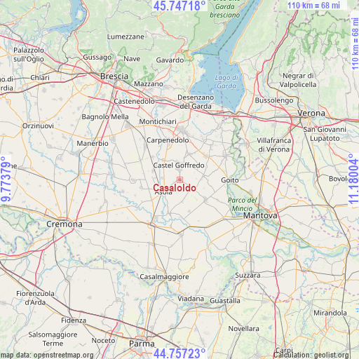
Casaloldo GPS coordinates[2]
45° 15' 15.696" North, 10° 28' 36.876" East
| Map corner | latitude | longitude |
|---|---|---|
| Upper-left | 45.74718°, | 9.77379° |
| Center: | 45.25436°, | 10.47691° |
| Lower-right: | 44.75723°, | 11.18004° |
| Map W x H: | 110.1×110.1 km | = 68.4×68.4mi |
| max Lat: | 47.04031° ⇑33.7% North |
| Casaloldo: | 45.25436° |
| min Lat: | ⇓66.3% South 35.50142° |
| min Long | Casaloldo | max Long |
| 6.69888° | 10.47691° | 18.48682° |
| W 36.9%⇐ | ⇒63.1% E |
Elevation
Elevation of Casaloldo is 47 m = 154 ft, and this is 259.7 m = 852 ft below average elevation for this country.
| Max E: |
2085 m = 6841 ft | 80.5% |
| Avg. | 306.7 m = 1006 ft | |
| Casaloldo | 47 m = 154 ft | |
Min E: |
-4 m = -13 ft | 19.5% |
See also: Italy elevation on elevation.city.
Geographical zone
Casaloldo is located in North temperate zone (between Tropic of Cancer and the Arctic Circle). Distance of this North polar circle is 2369.4 km =1472.3 mi to North.| Distance of | km | miles | from Casaloldo |
|---|---|---|---|
| North Pole | 4975.2 | 3091.4 | to North |
| Arctic Circle | 2369.4 | 1472.3 | to North |
| Tropic Cancer | 2425.9 | 1507.4 | to South |
| Equator | 5031.8 | 3126.6 | to South |


Nearby cities:
15 places around Casaloldo: (largest is in red/bold)
• Acquafredda
7.7 km =4.8 mi,  319°
319°
• Acquanegra sul Chiese
10.6 km =6.6 mi,  198°
198°
• Asola
6.3 km =3.9 mi,  233°
233°
• Casalmoro
5.2 km =3.2 mi,  278°
278°
• Castel Goffredo
4.4 km =2.7 mi,  356°
356°
• Castelnuovo
1.9 km =1.2 mi,  244°
244°
• Ceresara
7.3 km =4.5 mi,  83°
83°
• Gazoldo degli Ippoliti
10 km =6.2 mi,  127°
127°
• Mariana Mantovana
6.9 km =4.3 mi,  173°
173°
• Medole
8.5 km =5.3 mi,  19°
19°
• Piubega
5.3 km =3.3 mi, 125°
• Redondesco
10.2 km =6.3 mi,  164°
164°
• Remedello
8.6 km =5.3 mi,  288°
288°
• Remedello di Sopra
8.7 km =5.4 mi, 288°
• Remedello di Sotto
7.6 km =4.7 mi,  274°
274°
Sources, notices
• [Note1] Compared only with cities in Italy existing in our database
• [Src1] Map data: © OpenStreetMap contributors (CC-BY-SA)
• [Src2] Other city data from geonames.org with taken over terms of usage.
• [Src3] Geographical zone / Annual Mean Temperature by Robert A. Rohde @ Wikipedia
