Ceresara geodata
Ceresara (Lombardy) is a seat of a third-order administrative division; located in Italy in Europe/Rome (GMT+2) time zone. With population of 1,522 people, there are 5072 cities with bigger population in this country. Compared to other cities in Italy, 66.5% of cities are located further ↓South; 62.1% of cities are located further →East and 81.5% of cities have higher elevation than Ceresara. Note1


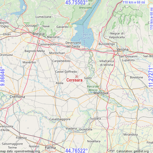
Ceresara GPS coordinates[2]
45° 15' 44.208" North, 10° 34' 10.488" East
| Map corner | latitude | longitude |
|---|---|---|
| Upper-left | 45.75503°, | 9.86646° |
| Center: | 45.26228°, | 10.56958° |
| Lower-right: | 44.76522°, | 11.27271° |
| Map W x H: | 110.1×110.1 km | = 68.4×68.4mi |
| max Lat: | 47.04031° ⇑33.5% North |
| Ceresara: | 45.26228° |
| min Lat: | ⇓66.5% South 35.50142° |
| min Long | Ceresara | max Long |
| 6.69888° | 10.56958° | 18.48682° |
| W 37.9%⇐ | ⇒62.1% E |
Elevation
Elevation of Ceresara is 44 m = 144 ft, and this is 262.7 m = 862 ft below average elevation for this country.
| Max E: |
2085 m = 6841 ft | 81.5% |
| Avg. | 306.7 m = 1006 ft | |
| Ceresara | 44 m = 144 ft | |
Min E: |
-4 m = -13 ft | 18.5% |
See also: Italy elevation on elevation.city.
Geographical zone
Ceresara is located in North temperate zone (between Tropic of Cancer and the Arctic Circle). Distance of this North polar circle is 2368.5 km =1471.7 mi to North.| Distance of | km | miles | from Ceresara |
|---|---|---|---|
| North Pole | 4974.4 | 3090.9 | to North |
| Arctic Circle | 2368.5 | 1471.7 | to North |
| Tropic Cancer | 2426.8 | 1507.9 | to South |
| Equator | 5032.7 | 3127.2 | to South |


Nearby cities:
15 places around Ceresara: (largest is in red/bold)
• Casaloldo
7.3 km =4.5 mi,  263°
263°
• Castel Goffredo
8.3 km =5.2 mi,  295°
295°
• Castelnuovo
9.1 km =5.7 mi, 259°
• Cavriana
9.7 km =6 mi,  12°
12°
• Cereta
7.4 km =4.6 mi,  49°
49°
• Cerlongo
6.5 km =4 mi,  73°
73°
• Gazoldo degli Ippoliti
7 km =4.3 mi,  174°
174°
• Goito
7.3 km =4.5 mi,  100°
100°
• Guidizzolo
6.5 km =4 mi, 5°
• Mariana Mantovana
10.1 km =6.3 mi,  220°
220°
• Medole
8.3 km =5.2 mi,  328°
328°
• Piubega
4.9 km =3 mi, 216°
• Redondesco
11.6 km =7.2 mi,  202°
202°
• Rodigo
8.3 km =5.2 mi,  148°
148°
• Volta Mantovana
9.6 km =6 mi, 46°
Sources, notices
• [Note1] Compared only with cities in Italy existing in our database
• [Src1] Map data: © OpenStreetMap contributors (CC-BY-SA)
• [Src2] Other city data from geonames.org with taken over terms of usage.
• [Src3] Geographical zone / Annual Mean Temperature by Robert A. Rohde @ Wikipedia
