Castelnuovo geodata
Castelnuovo (Lombardy) is a populated place; located in Italy in Europe/Rome (GMT+2) time zone. With population of 1,000 people, there are 6662 cities with bigger population in this country. Compared to other cities in Italy, 66.1% of cities are located further ↓South; 63.4% of cities are located further →East and 81.5% of cities have higher elevation than Castelnuovo. Note1


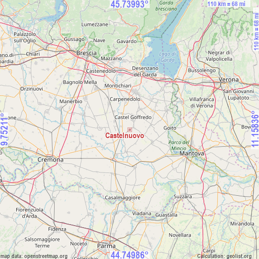
Castelnuovo GPS coordinates[2]
45° 14' 49.38" North, 10° 27' 18.828" East
| Map corner | latitude | longitude |
|---|---|---|
| Upper-left | 45.73993°, | 9.75211° |
| Center: | 45.24705°, | 10.45523° |
| Lower-right: | 44.74986°, | 11.15836° |
| Map W x H: | 110.1×110.1 km | = 68.4×68.4mi |
| max Lat: | 47.04031° ⇑33.9% North |
| Castelnuovo: | 45.24705° |
| min Lat: | ⇓66.1% South 35.50142° |
| min Long | Castelnuovo | max Long |
| 6.69888° | 10.45523° | 18.48682° |
| W 36.6%⇐ | ⇒63.4% E |
Elevation
Elevation of Castelnuovo is 44 m = 144 ft, and this is 262.7 m = 862 ft below average elevation for this country.
| Max E: |
2085 m = 6841 ft | 81.5% |
| Avg. | 306.7 m = 1006 ft | |
| Castelnuovo | 44 m = 144 ft | |
Min E: |
-4 m = -13 ft | 18.5% |
See also: Italy elevation on elevation.city.
Geographical zone
Castelnuovo is located in North temperate zone (between Tropic of Cancer and the Arctic Circle). Distance of this North polar circle is 2370.2 km =1472.8 mi to North.| Distance of | km | miles | from Castelnuovo |
|---|---|---|---|
| North Pole | 4976.1 | 3092 | to North |
| Arctic Circle | 2370.2 | 1472.8 | to North |
| Tropic Cancer | 2425.1 | 1506.9 | to South |
| Equator | 5031 | 3126.1 | to South |


Nearby cities:
15 places around Castelnuovo: (largest is in red/bold)
• Acquafredda
7.4 km =4.6 mi,  333°
333°
• Acquanegra sul Chiese
9.4 km =5.8 mi,  190°
190°
• Asola
4.5 km =2.8 mi,  228°
228°
• Casalmoro
3.8 km =2.4 mi,  294°
294°
• Casaloldo
1.9 km =1.2 mi,  64°
64°
• Casalromano
8.8 km =5.5 mi, 231°
• Castel Goffredo
5.4 km =3.4 mi,  14°
14°
• Ceresara
9.1 km =5.7 mi,  79°
79°
• Mariana Mantovana
6.5 km =4 mi,  157°
157°
• Medole
9.9 km =6.2 mi,  27°
27°
• Piubega
6.4 km =4 mi,  110°
110°
• Redondesco
10 km =6.2 mi,  153°
153°
• Remedello
7.4 km =4.6 mi,  298°
298°
• Remedello di Sopra
7.5 km =4.7 mi, 298°
• Remedello di Sotto
6 km =3.7 mi,  283°
283°
Sources, notices
• [Note1] Compared only with cities in Italy existing in our database
• [Src1] Map data: © OpenStreetMap contributors (CC-BY-SA)
• [Src2] Other city data from geonames.org with taken over terms of usage.
• [Src3] Geographical zone / Annual Mean Temperature by Robert A. Rohde @ Wikipedia
