Carrara geodata
Carrara (Tuscany) is a seat of a third-order administrative division; located in Italy in Europe/Rome (GMT+2) time zone. With population of 58,666 people, there are 89 cities with bigger population in this country. Compared to other cities in Italy, 53.9% of cities are located further ↑North; 66.9% of cities are located further →East and 69.9% of cities have higher elevation than Carrara. Note1


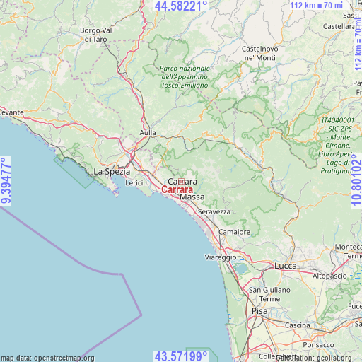
Carrara GPS coordinates[2]
44° 4' 45.336" North, 10° 5' 52.404" East
| Map corner | latitude | longitude |
|---|---|---|
| Upper-left | 44.58221°, | 9.39477° |
| Center: | 44.07926°, | 10.09789° |
| Lower-right: | 43.57199°, | 10.80102° |
| Map W x H: | 112.3×112.3 km | = 69.8×69.8mi |
| max Lat: | 47.04031° ⇑53.9% North |
| Carrara: | 44.07926° |
| min Lat: | ⇓46.1% South 35.50142° |
| min Long | Carrara | max Long |
| 6.69888° | 10.09789° | 18.48682° |
| W 33.1%⇐ | ⇒66.9% E |
Elevation
Elevation of Carrara is 98 m = 322 ft, and this is 208.7 m = 685 ft below average elevation for this country.
| Max E: |
2085 m = 6841 ft | 69.9% |
| Avg. | 306.7 m = 1006 ft | |
| Carrara | 98 m = 322 ft | |
Min E: |
-4 m = -13 ft | 30.1% |
See also: Carrara elevation on elevation.city.
Geographical zone
Carrara is located in North temperate zone (between Tropic of Cancer and the Arctic Circle). Distance of this Northern Tropic circle is 2295.2 km =1426.2 mi to South.| Distance of | km | miles | from Carrara |
|---|---|---|---|
| North Pole | 5105.9 | 3172.7 | to North |
| Arctic Circle | 2500 | 1553.4 | to North |
| Tropic Cancer | 2295.2 | 1426.2 | to South |
| Equator | 4901.2 | 3045.5 | to South |


Nearby cities:
15 places around Carrara: (largest is in red/bold)
• Bedizzano
2.1 km =1.3 mi,  91°
91°
• Casano-Dogana-Isola
5.1 km =3.2 mi,  265°
265°
• Casette
5.6 km =3.5 mi, 94°
• Castelnuovo Magra
6.8 km =4.2 mi,  289°
289°
• Codena
1.2 km =0.7 mi,  98°
98°
• Colombiera-Molicciara
7.1 km =4.4 mi,  277°
277°
• Forno
6.4 km =4 mi, 86°
• Gragnana
2.4 km =1.5 mi,  337°
337°
• Luni Mare
7.9 km =4.9 mi,  253°
253°
• Marina di Carrara
6.4 km =4 mi,  224°
224°
• Marina di Massa
8.4 km =5.2 mi,  175°
175°
• Massa
5.9 km =3.7 mi,  145°
145°
• Montignoso
8.6 km =5.3 mi,  135°
135°
• San Vito-Cerreto
8.6 km =5.3 mi, 136°
• Torano
1.5 km =0.9 mi,  19°
19°
Sources, notices
• [Note1] Compared only with cities in Italy existing in our database
• [Src1] Map data: © OpenStreetMap contributors (CC-BY-SA)
• [Src2] Other city data from geonames.org with taken over terms of usage.
• [Src3] Geographical zone / Annual Mean Temperature by Robert A. Rohde @ Wikipedia
