Colombiera-Molicciara geodata
Colombiera-Molicciara (Liguria) is a populated place; located in Italy in Europe/Rome (GMT+2) time zone. With population of 6,945 people, there are 1406 cities with bigger population in this country. Compared to other cities in Italy, 53.8% of cities are located further ↑North; 67.7% of cities are located further →East and 87.4% of cities have higher elevation than Colombiera-Molicciara. Note1
Administrative division(s):
- Level 1: Liguria
- Level 2: Provincia di La Spezia
- Level 3: Castelnuovo Magra


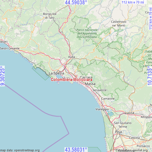
Colombiera-Molicciara GPS coordinates[2]
44° 5' 15" North, 10° 0' 37.332" East
| Map corner | latitude | longitude |
|---|---|---|
| Upper-left | 44.59038°, | 9.30725° |
| Center: | 44.0875°, | 10.01037° |
| Lower-right: | 43.58031°, | 10.7135° |
| Map W x H: | 112.3×112.3 km | = 69.8×69.8mi |
| max Lat: | 47.04031° ⇑53.8% North |
| Colombiera-Molicciara: | 44.0875° |
| min Lat: | ⇓46.2% South 35.50142° |
| min Long | Colombiera-Moli | max Long |
| 6.69888° | 10.01037° | 18.48682° |
| W 32.3%⇐ | ⇒67.7% E |
Elevation
Elevation of Colombiera-Molicciara is 24 m = 79 ft, and this is 282.7 m = 927 ft below average elevation for this country.
| Max E: |
2085 m = 6841 ft | 87.4% |
| Avg. | 306.7 m = 1006 ft | |
| Colombiera-Molicciara | 24 m = 79 ft | |
Min E: |
-4 m = -13 ft | 12.6% |
See also: Italy elevation on elevation.city.
Geographical zone
Colombiera-Molicciara is located in North temperate zone (between Tropic of Cancer and the Arctic Circle). Distance of this Northern Tropic circle is 2296.2 km =1426.8 mi to South.| Distance of | km | miles | from Colombiera-Molicciara |
|---|---|---|---|
| North Pole | 5105 | 3172.1 | to North |
| Arctic Circle | 2499.1 | 1552.9 | to North |
| Tropic Cancer | 2296.2 | 1426.8 | to South |
| Equator | 4902.1 | 3046 | to South |


Nearby cities:
15 places around Colombiera-Molicciara: (largest is in red/bold)
• Ameglia
4 km =2.5 mi,  242°
242°
• Borghetto-Melara
2 km =1.2 mi,  307°
307°
• Carrara
7.1 km =4.4 mi,  97°
97°
• Casano-Dogana-Isola
2.3 km =1.4 mi,  125°
125°
• Castelnuovo Magra
1.4 km =0.9 mi,  21°
21°
• Fiumaretta di Ameglia
4.2 km =2.6 mi,  203°
203°
• Fosdinovo
5.1 km =3.2 mi,  6°
6°
• Gragnana
6.2 km =3.9 mi,  77°
77°
• Lerici
8 km =5 mi,  260°
260°
• Luni Mare
3.2 km =2 mi,  190°
190°
• Marina di Carrara
6 km =3.7 mi,  155°
155°
• Romito Magra
6.4 km =4 mi,  280°
280°
• Sarzana
4.7 km =2.9 mi, 305°
• Tellaro
7.2 km =4.5 mi,  246°
246°
• Torano
7.5 km =4.7 mi,  85°
85°
Sources, notices
• [Note1] Compared only with cities in Italy existing in our database
• [Src1] Map data: © OpenStreetMap contributors (CC-BY-SA)
• [Src2] Other city data from geonames.org with taken over terms of usage.
• [Src3] Geographical zone / Annual Mean Temperature by Robert A. Rohde @ Wikipedia
