Carema geodata
Carema (Piedmont) is a seat of a third-order administrative division; located in Italy in Europe/Rome (GMT+2) time zone. With population of 698 people, there are 8314 cities with bigger population in this country. Compared to other cities in Italy, 76.4% of cities are located further ↓South; 95.5% of cities are located further →East and 61.5% of cities have lower elevation than Carema. Note1


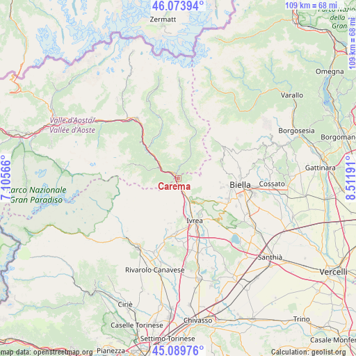
Carema GPS coordinates[2]
45° 35' 2.436" North, 7° 48' 31.644" East
| Map corner | latitude | longitude |
|---|---|---|
| Upper-left | 46.07394°, | 7.10566° |
| Center: | 45.58401°, | 7.80879° |
| Lower-right: | 45.08976°, | 8.51191° |
| Map W x H: | 109.4×109.4 km | = 68×68mi |
| max Lat: | 47.04031° ⇑23.6% North |
| Carema: | 45.58401° |
| min Lat: | ⇓76.4% South 35.50142° |
| min Long | Carema | max Long |
| 6.69888° | 7.80879° | 18.48682° |
| W 4.5%⇐ | ⇒95.5% E |
Elevation
Elevation of Carema is 311 m = 1020 ft, and this is 4.3 m = 14 ft above average elevation for this country.
| Max E: |
2085 m = 6841 ft | 38.5% |
| Carema | 311 m 1020 ft | |
| Avg. | 306.7 m = 1006 ft | |
Min E: |
-4 m = -13 ft | 61.5% |
See also: Italy elevation on elevation.city.
Geographical zone
Carema is located in North temperate zone (between Tropic of Cancer and the Arctic Circle). Distance of this North polar circle is 2332.7 km =1449.5 mi to North.| Distance of | km | miles | from Carema |
|---|---|---|---|
| North Pole | 4938.6 | 3068.7 | to North |
| Arctic Circle | 2332.7 | 1449.5 | to North |
| Tropic Cancer | 2462.5 | 1530.1 | to South |
| Equator | 5068.5 | 3149.4 | to South |


Nearby cities:
15 places around Carema: (largest is in red/bold)
• Andrate
8.6 km =5.3 mi,  138°
138°
• Bard
5.7 km =3.5 mi,  299°
299°
• Borgofranco d'Ivrea
8.5 km =5.3 mi,  152°
152°
• Donnas
3.4 km =2.1 mi,  308°
308°
• Fontainemore
8.1 km =5 mi,  29°
29°
• Hone
6.4 km =4 mi, 301°
• Lillianes
5.7 km =3.5 mi, 26°
• Nomaglio
6.7 km =4.2 mi, 142°
• Perloz
3.3 km =2.1 mi,  359°
359°
• Pont-Saint-Martin
1.7 km =1.1 mi,  318°
318°
• Quassolo
7 km =4.3 mi,  164°
164°
• Quincinetto
2.5 km =1.6 mi,  180°
180°
• Settimo Vittone
4.3 km =2.7 mi, 153°
• Tavagnasco
4.5 km =2.8 mi,  165°
165°
• Traversella
9.5 km =5.9 mi,  209°
209°
Sources, notices
• [Note1] Compared only with cities in Italy existing in our database
• [Src1] Map data: © OpenStreetMap contributors (CC-BY-SA)
• [Src2] Other city data from geonames.org with taken over terms of usage.
• [Src3] Geographical zone / Annual Mean Temperature by Robert A. Rohde @ Wikipedia
