Hone geodata
Hone (Aosta Valley) is a seat of a third-order administrative division; located in Italy in Europe/Rome (GMT+2) time zone. With population of 1,115 people, there are 6233 cities with bigger population in this country. Compared to other cities in Italy, 77.7% of cities are located further ↓South; 96.1% of cities are located further →East and 66.5% of cities have lower elevation than Hone. Note1


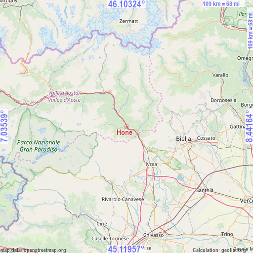
Hone GPS coordinates[2]
45° 36' 48.816" North, 7° 44' 18.636" East
| Map corner | latitude | longitude |
|---|---|---|
| Upper-left | 46.10324°, | 7.03539° |
| Center: | 45.61356°, | 7.73851° |
| Lower-right: | 45.11957°, | 8.44164° |
| Map W x H: | 109.4×109.4 km | = 68×68mi |
| max Lat: | 47.04031° ⇑22.3% North |
| Hone: | 45.61356° |
| min Lat: | ⇓77.7% South 35.50142° |
| min Long | Hone | max Long |
| 6.69888° | 7.73851° | 18.48682° |
| W 3.9%⇐ | ⇒96.1% E |
Elevation
Elevation of Hone is 358 m = 1175 ft, and this is 51.3 m = 168 ft above average elevation for this country.
| Max E: |
2085 m = 6841 ft | 33.5% |
| Hone | 358 m 1175 ft | |
| Avg. | 306.7 m = 1006 ft | |
Min E: |
-4 m = -13 ft | 66.5% |
See also: Italy elevation on elevation.city.
Geographical zone
Hone is located in North temperate zone (between Tropic of Cancer and the Arctic Circle). Distance of this North polar circle is 2329.4 km =1447.4 mi to North.| Distance of | km | miles | from Hone |
|---|---|---|---|
| North Pole | 4935.3 | 3066.7 | to North |
| Arctic Circle | 2329.4 | 1447.4 | to North |
| Tropic Cancer | 2465.8 | 1532.2 | to South |
| Equator | 5071.8 | 3151.5 | to South |


Nearby cities:
15 places around Hone: (largest is in red/bold)
• Arnad
4.1 km =2.5 mi,  335°
335°
• Bard
0.7 km =0.4 mi,  133°
133°
• Carema
6.4 km =4 mi,  121°
121°
• Challand-Saint-Victor
8.9 km =5.5 mi, 342°
• Champorcher
9.2 km =5.7 mi,  277°
277°
• Donnas
3.1 km =1.9 mi,  112°
112°
• Issogne
6.2 km =3.9 mi,  318°
318°
• La Place
6.2 km =3.9 mi, 316°
• Lillianes
8.2 km =5.1 mi,  77°
77°
• Perloz
5.4 km =3.4 mi,  89°
89°
• Pont-Bozet
4.1 km =2.5 mi,  260°
260°
• Pont-Saint-Martin
4.8 km =3 mi, 114°
• Quincinetto
7.9 km =4.9 mi,  136°
136°
• Verres
7 km =4.3 mi,  326°
326°
• Villa-Nabian
8.9 km =5.5 mi, 342°
Sources, notices
• [Note1] Compared only with cities in Italy existing in our database
• [Src1] Map data: © OpenStreetMap contributors (CC-BY-SA)
• [Src2] Other city data from geonames.org with taken over terms of usage.
• [Src3] Geographical zone / Annual Mean Temperature by Robert A. Rohde @ Wikipedia
