Carbonera geodata
Carbonera (Veneto) is a seat of a third-order administrative division; located in Italy in Europe/Rome (GMT+1) time zone. With population of 4,276 people, there are 2248 cities with bigger population in this country. Compared to other cities in Italy, 80.8% of cities are located further ↓South; 59.6% of cities are located further ←West and 90.1% of cities have higher elevation than Carbonera. Note1


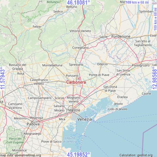
Carbonera GPS coordinates[2]
45° 41' 30.552" North, 12° 16' 57.18" East
| Map corner | latitude | longitude |
|---|---|---|
| Upper-left | 46.18081°, | 11.57943° |
| Center: | 45.69182°, | 12.28255° |
| Lower-right: | 45.19852°, | 12.98568° |
| Map W x H: | 109.2×109.2 km | = 67.9×67.9mi |
| max Lat: | 47.04031° ⇑19.2% North |
| Carbonera: | 45.69182° |
| min Lat: | ⇓80.8% South 35.50142° |
| min Long | Carbonera | max Long |
| 6.69888° | 12.28255° | 18.48682° |
| W 59.6%⇐ | ⇒40.4% E |
Elevation
Elevation of Carbonera is 18 m = 59 ft, and this is 288.7 m = 947 ft below average elevation for this country.
| Max E: |
2085 m = 6841 ft | 90.1% |
| Avg. | 306.7 m = 1006 ft | |
| Carbonera | 18 m = 59 ft | |
Min E: |
-4 m = -13 ft | 9.9% |
See also: Italy elevation on elevation.city.
Geographical zone
Carbonera is located in North temperate zone (between Tropic of Cancer and the Arctic Circle). Distance of this North polar circle is 2320.7 km =1442 mi to North.| Distance of | km | miles | from Carbonera |
|---|---|---|---|
| North Pole | 4926.6 | 3061.2 | to North |
| Arctic Circle | 2320.7 | 1442 | to North |
| Tropic Cancer | 2474.5 | 1537.6 | to South |
| Equator | 5080.5 | 3156.9 | to South |


Nearby cities:
15 places around Carbonera: (largest is in red/bold)
• Breda
5.1 km =3.2 mi,  47°
47°
• Casier
5.6 km =3.5 mi,  171°
171°
• Dosson
6.6 km =4.1 mi,  199°
199°
• Lancenigo-Villorba
3.1 km =1.9 mi,  319°
319°
• Mignagola
3 km =1.9 mi,  96°
96°
• Pero
5.4 km =3.4 mi,  72°
72°
• Pezzan
1 km =0.6 mi, 47°
• Ponzano
6.6 km =4.1 mi,  293°
293°
• San Floriano-Olmi
4.2 km =2.6 mi,  118°
118°
• San Giacomo di Musestrelle
4.3 km =2.7 mi, 69°
• Silea
4.3 km =2.7 mi,  164°
164°
• Treviso
4.2 km =2.6 mi,  228°
228°
• Vacil
2.9 km =1.8 mi, 45°
• Varago
5.5 km =3.4 mi,  23°
23°
• Vascon
3.4 km =2.1 mi,  12°
12°
Sources, notices
• [Note1] Compared only with cities in Italy existing in our database
• [Src1] Map data: © OpenStreetMap contributors (CC-BY-SA)
• [Src2] Other city data from geonames.org with taken over terms of usage.
• [Src3] Geographical zone / Annual Mean Temperature by Robert A. Rohde @ Wikipedia
