Ponzano geodata
Ponzano (Veneto) is a seat of a third-order administrative division; located in Italy in Europe/Rome (GMT+2) time zone. With population of 10,238 people, there are 926 cities with bigger population in this country. Compared to other cities in Italy, 81.9% of cities are located further ↓South; 58.7% of cities are located further ←West and 83.7% of cities have higher elevation than Ponzano. Note1


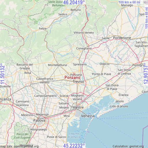
Ponzano GPS coordinates[2]
45° 42' 55.476" North, 12° 12' 15.984" East
| Map corner | latitude | longitude |
|---|---|---|
| Upper-left | 46.20419°, | 11.50132° |
| Center: | 45.71541°, | 12.20444° |
| Lower-right: | 45.22232°, | 12.90757° |
| Map W x H: | 109.2×109.2 km | = 67.9×67.9mi |
| max Lat: | 47.04031° ⇑18.1% North |
| Ponzano: | 45.71541° |
| min Lat: | ⇓81.9% South 35.50142° |
| min Long | Ponzano | max Long |
| 6.69888° | 12.20444° | 18.48682° |
| W 58.7%⇐ | ⇒41.3% E |
Elevation
Elevation of Ponzano is 35 m = 115 ft, and this is 271.7 m = 891 ft below average elevation for this country.
| Max E: |
2085 m = 6841 ft | 83.7% |
| Avg. | 306.7 m = 1006 ft | |
| Ponzano | 35 m = 115 ft | |
Min E: |
-4 m = -13 ft | 16.3% |
See also: Italy elevation on elevation.city.
Geographical zone
Ponzano is located in North temperate zone (between Tropic of Cancer and the Arctic Circle). Distance of this North polar circle is 2318.1 km =1440.4 mi to North.| Distance of | km | miles | from Ponzano |
|---|---|---|---|
| North Pole | 4924 | 3059.6 | to North |
| Arctic Circle | 2318.1 | 1440.4 | to North |
| Tropic Cancer | 2477.2 | 1539.3 | to South |
| Equator | 5083.1 | 3158.5 | to South |


Nearby cities:
15 places around Ponzano: (largest is in red/bold)
• Camalò
4.9 km =3 mi,  328°
328°
• Carbonera
6.6 km =4.1 mi,  113°
113°
• Castagnole
3.4 km =2.1 mi,  209°
209°
• Lancenigo-Villorba
4.1 km =2.5 mi,  93°
93°
• Musano
6.8 km =4.2 mi,  280°
280°
• Paese
5.6 km =3.5 mi, 214°
• Pezzan
7.1 km =4.4 mi, 106°
• Porcellengo
4.9 km =3 mi,  257°
257°
• Postioma
4.1 km =2.5 mi,  273°
273°
• Povegliano
4.9 km =3 mi,  4°
4°
• San Rocco
6.3 km =3.9 mi,  354°
354°
• Santandrà
3.6 km =2.2 mi,  355°
355°
• Treviso
6.1 km =3.8 mi,  151°
151°
• Vascon
6.8 km =4.2 mi,  84°
84°
• Visnadello
5.8 km =3.6 mi,  34°
34°
Sources, notices
• [Note1] Compared only with cities in Italy existing in our database
• [Src1] Map data: © OpenStreetMap contributors (CC-BY-SA)
• [Src2] Other city data from geonames.org with taken over terms of usage.
• [Src3] Geographical zone / Annual Mean Temperature by Robert A. Rohde @ Wikipedia
