Capergnanica geodata
Capergnanica (Lombardy) is a seat of a third-order administrative division; located in Italy in Europe/Rome (GMT+2) time zone. With population of 1,622 people, there are 4843 cities with bigger population in this country. Compared to other cities in Italy, 68.5% of cities are located further ↓South; 71.4% of cities are located further →East and 74.3% of cities have higher elevation than Capergnanica. Note1


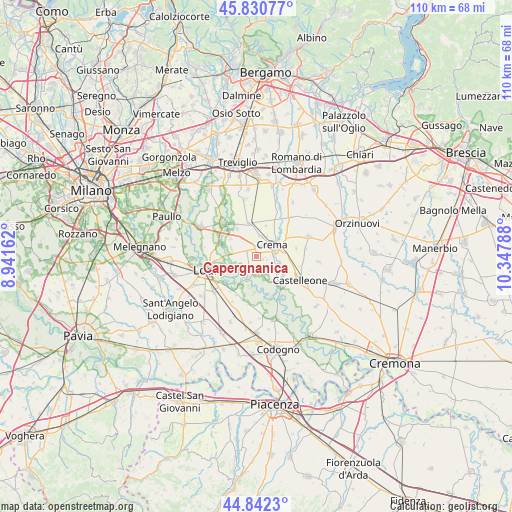
Capergnanica GPS coordinates[2]
45° 20' 19.284" North, 9° 38' 41.1" East
| Map corner | latitude | longitude |
|---|---|---|
| Upper-left | 45.83077°, | 8.94162° |
| Center: | 45.33869°, | 9.64475° |
| Lower-right: | 44.8423°, | 10.34788° |
| Map W x H: | 109.9×109.9 km | = 68.3×68.3mi |
| max Lat: | 47.04031° ⇑31.5% North |
| Capergnanica: | 45.33869° |
| min Lat: | ⇓68.5% South 35.50142° |
| min Long | Capergnanica | max Long |
| 6.69888° | 9.64475° | 18.48682° |
| W 28.6%⇐ | ⇒71.4% E |
Elevation
Elevation of Capergnanica is 77 m = 253 ft, and this is 229.7 m = 754 ft below average elevation for this country.
| Max E: |
2085 m = 6841 ft | 74.3% |
| Avg. | 306.7 m = 1006 ft | |
| Capergnanica | 77 m = 253 ft | |
Min E: |
-4 m = -13 ft | 25.7% |
See also: Italy elevation on elevation.city.
Geographical zone
Capergnanica is located in North temperate zone (between Tropic of Cancer and the Arctic Circle). Distance of this North polar circle is 2360 km =1466.4 mi to North.| Distance of | km | miles | from Capergnanica |
|---|---|---|---|
| North Pole | 4965.9 | 3085.7 | to North |
| Arctic Circle | 2360 | 1466.4 | to North |
| Tropic Cancer | 2435.3 | 1513.2 | to South |
| Equator | 5041.2 | 3132.5 | to South |


Nearby cities:
15 places around Capergnanica: (largest is in red/bold)
• Abbadia Cerreto
4.9 km =3 mi,  233°
233°
• Bagnolo Cremasco
3.5 km =2.2 mi,  315°
315°
• Bolzone
1.4 km =0.9 mi,  108°
108°
• Casaletto Ceredano
3.1 km =1.9 mi,  223°
223°
• Chieve
2.2 km =1.4 mi,  275°
275°
• Credera
4 km =2.5 mi,  168°
168°
• Crema
3.9 km =2.4 mi,  47°
47°
• Crespiatica
5.5 km =3.4 mi, 284°
• Madignano
6.1 km =3.8 mi,  83°
83°
• Moscazzano
5.8 km =3.6 mi,  150°
150°
• Ripalta Guerina
5.9 km =3.7 mi,  128°
128°
• Ripalta Nuova
3.8 km =2.4 mi,  101°
101°
• Santo Stefano in Vairano
5.1 km =3.2 mi,  28°
28°
• Vaiano Cremasco
5.7 km =3.5 mi,  309°
309°
• Zappello
2.3 km =1.4 mi, 104°
Sources, notices
• [Note1] Compared only with cities in Italy existing in our database
• [Src1] Map data: © OpenStreetMap contributors (CC-BY-SA)
• [Src2] Other city data from geonames.org with taken over terms of usage.
• [Src3] Geographical zone / Annual Mean Temperature by Robert A. Rohde @ Wikipedia
