Chieve geodata
Chieve (Lombardy) is a seat of a third-order administrative division; located in Italy in Europe/Rome (GMT+2) time zone. With population of 2,200 people, there are 3870 cities with bigger population in this country. Compared to other cities in Italy, 68.6% of cities are located further ↓South; 71.7% of cities are located further →East and 74% of cities have higher elevation than Chieve. Note1


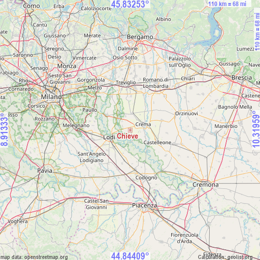
Chieve GPS coordinates[2]
45° 20' 25.692" North, 9° 36' 59.256" East
| Map corner | latitude | longitude |
|---|---|---|
| Upper-left | 45.83253°, | 8.91333° |
| Center: | 45.34047°, | 9.61646° |
| Lower-right: | 44.84409°, | 10.31959° |
| Map W x H: | 109.9×109.9 km | = 68.3×68.3mi |
| max Lat: | 47.04031° ⇑31.4% North |
| Chieve: | 45.34047° |
| min Lat: | ⇓68.6% South 35.50142° |
| min Long | Chieve | max Long |
| 6.69888° | 9.61646° | 18.48682° |
| W 28.3%⇐ | ⇒71.7% E |
Elevation
Elevation of Chieve is 78 m = 256 ft, and this is 228.7 m = 750 ft below average elevation for this country.
| Max E: |
2085 m = 6841 ft | 74% |
| Avg. | 306.7 m = 1006 ft | |
| Chieve | 78 m = 256 ft | |
Min E: |
-4 m = -13 ft | 26% |
See also: Italy elevation on elevation.city.
Geographical zone
Chieve is located in North temperate zone (between Tropic of Cancer and the Arctic Circle). Distance of this North polar circle is 2359.8 km =1466.3 mi to North.| Distance of | km | miles | from Chieve |
|---|---|---|---|
| North Pole | 4965.7 | 3085.5 | to North |
| Arctic Circle | 2359.8 | 1466.3 | to North |
| Tropic Cancer | 2435.5 | 1513.3 | to South |
| Equator | 5041.4 | 3132.6 | to South |


Nearby cities:
15 places around Chieve: (largest is in red/bold)
• Abbadia Cerreto
3.6 km =2.2 mi,  208°
208°
• Bagnolo Cremasco
2.3 km =1.4 mi,  353°
353°
• Bolzone
3.6 km =2.2 mi,  100°
100°
• Cadilana
5.7 km =3.5 mi,  258°
258°
• Capergnanica
2.2 km =1.4 mi, 95°
• Casaletto Ceredano
2.5 km =1.6 mi,  179°
179°
• Credera
5.1 km =3.2 mi,  144°
144°
• Crema
5.7 km =3.5 mi,  64°
64°
• Crespiatica
3.3 km =2.1 mi,  291°
291°
• Monte Cremasco
4.9 km =3 mi,  316°
316°
• Ripalta Nuova
6 km =3.7 mi, 98°
• Scannabue-Cascine Capri
6.1 km =3.8 mi,  342°
342°
• Terraverde-Corte Palasio
5.1 km =3.2 mi,  237°
237°
• Vaiano Cremasco
4.1 km =2.5 mi,  326°
326°
• Zappello
4.5 km =2.8 mi, 100°
Sources, notices
• [Note1] Compared only with cities in Italy existing in our database
• [Src1] Map data: © OpenStreetMap contributors (CC-BY-SA)
• [Src2] Other city data from geonames.org with taken over terms of usage.
• [Src3] Geographical zone / Annual Mean Temperature by Robert A. Rohde @ Wikipedia
