Capalbio geodata
Capalbio (Tuscany) is a seat of a third-order administrative division; located in Italy in Europe/Rome (GMT+2) time zone. With population of 630 people, there are 8773 cities with bigger population in this country. Compared to other cities in Italy, 66.6% of cities are located further ↑North; 51.6% of cities are located further →East and 59.4% of cities have higher elevation than Capalbio. Note1


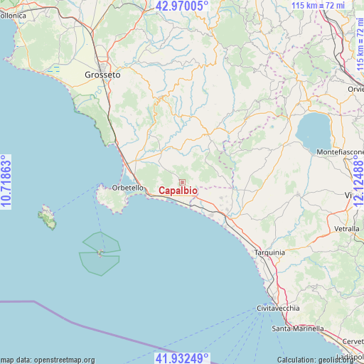
Capalbio GPS coordinates[2]
42° 27' 12.312" North, 11° 25' 18.3" East
| Map corner | latitude | longitude |
|---|---|---|
| Upper-left | 42.97005°, | 10.71863° |
| Center: | 42.45342°, | 11.42175° |
| Lower-right: | 41.93249°, | 12.12488° |
| Map W x H: | 115.4×115.4 km | = 71.7×71.7mi |
| max Lat: | 47.04031° ⇑66.6% North |
| Capalbio: | 42.45342° |
| min Lat: | ⇓33.4% South 35.50142° |
| min Long | Capalbio | max Long |
| 6.69888° | 11.42175° | 18.48682° |
| W 48.4%⇐ | ⇒51.6% E |
Elevation
Elevation of Capalbio is 168 m = 551 ft, and this is 138.7 m = 455 ft below average elevation for this country.
| Max E: |
2085 m = 6841 ft | 59.4% |
| Avg. | 306.7 m = 1006 ft | |
| Capalbio | 168 m = 551 ft | |
Min E: |
-4 m = -13 ft | 40.6% |
See also: Italy elevation on elevation.city.
Geographical zone
Capalbio is located in North temperate zone (between Tropic of Cancer and the Arctic Circle). Distance of this Northern Tropic circle is 2114.5 km =1313.9 mi to South.| Distance of | km | miles | from Capalbio |
|---|---|---|---|
| North Pole | 5286.7 | 3285 | to North |
| Arctic Circle | 2680.8 | 1665.8 | to North |
| Tropic Cancer | 2114.5 | 1313.9 | to South |
| Equator | 4720.4 | 2933.1 | to South |


Nearby cities:
15 places around Capalbio: (largest is in red/bold)
• Albinia
18.2 km =11.3 mi,  287°
287°
• Capalbio Scalo
6.3 km =3.9 mi,  220°
220°
• Farnese
27.2 km =16.9 mi,  66°
66°
• Fonteblanda
23.8 km =14.8 mi,  301°
301°
• Magliano in Toscana
19.3 km =12 mi,  326°
326°
• Manciano
17 km =10.6 mi,  27°
27°
• Montalto di Castro
19.1 km =11.9 mi,  127°
127°
• Monte Argentario
24.9 km =15.5 mi,  265°
265°
• Montiano
26.8 km =16.7 mi,  322°
322°
• Orbetello
16.5 km =10.3 mi, 265°
• Orbetello Scalo
14.2 km =8.8 mi, 267°
• Pescia Romana
8.6 km =5.3 mi, 134°
• Porto Ercole
18.7 km =11.6 mi,  252°
252°
• Porto Santo Stefano
25.2 km =15.7 mi, 266°
• Scansano
27.1 km =16.8 mi,  343°
343°
Sources, notices
• [Note1] Compared only with cities in Italy existing in our database
• [Src1] Map data: © OpenStreetMap contributors (CC-BY-SA)
• [Src2] Other city data from geonames.org with taken over terms of usage.
• [Src3] Geographical zone / Annual Mean Temperature by Robert A. Rohde @ Wikipedia
