Scansano geodata
Scansano (Tuscany) is a seat of a third-order administrative division; located in Italy in Europe/Rome (GMT+2) time zone. With population of 1,447 people, there are 5253 cities with bigger population in this country. Compared to other cities in Italy, 65.2% of cities are located further ↑North; 52.8% of cities are located further →East and 81.7% of cities have lower elevation than Scansano. Note1


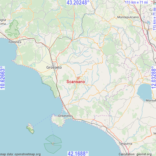
Scansano GPS coordinates[2]
42° 41' 16.044" North, 11° 19' 47.1" East
| Map corner | latitude | longitude |
|---|---|---|
| Upper-left | 43.20248°, | 10.62663° |
| Center: | 42.68779°, | 11.32975° |
| Lower-right: | 42.1688°, | 12.03288° |
| Map W x H: | 114.9×114.9 km | = 71.4×71.4mi |
| max Lat: | 47.04031° ⇑65.2% North |
| Scansano: | 42.68779° |
| min Lat: | ⇓34.8% South 35.50142° |
| min Long | Scansano | max Long |
| 6.69888° | 11.32975° | 18.48682° |
| W 47.2%⇐ | ⇒52.8% E |
Elevation
Elevation of Scansano is 548 m = 1798 ft, and this is 241.3 m = 792 ft above average elevation for this country.
| Max E: |
2085 m = 6841 ft | 18.3% |
| Scansano | 548 m 1798 ft | |
| Avg. | 306.7 m = 1006 ft | |
Min E: |
-4 m = -13 ft | 81.7% |
See also: Italy elevation on elevation.city.
Geographical zone
Scansano is located in North temperate zone (between Tropic of Cancer and the Arctic Circle). Distance of this Northern Tropic circle is 2140.5 km =1330 mi to South.| Distance of | km | miles | from Scansano |
|---|---|---|---|
| North Pole | 5260.6 | 3268.8 | to North |
| Arctic Circle | 2654.7 | 1649.6 | to North |
| Tropic Cancer | 2140.5 | 1330 | to South |
| Equator | 4746.4 | 2949.3 | to South |


Nearby cities:
15 places around Scansano: (largest is in red/bold)
• Albinia
22.8 km =14.2 mi,  205°
205°
• Bagno Roselle
20.8 km =12.9 mi,  311°
311°
• Batignano
23.9 km =14.9 mi,  326°
326°
• Campagnatico
22.2 km =13.8 mi,  348°
348°
• Cinigiano
23.1 km =14.4 mi,  12°
12°
• Fonteblanda
18.7 km =11.6 mi,  223°
223°
• Grosseto
19.8 km =12.3 mi,  294°
294°
• Istia D'Ombrone-Le Stiacciole
15.6 km =9.7 mi, 312°
• Magliano in Toscana
10.4 km =6.5 mi,  197°
197°
• Manciano
18.9 km =11.7 mi,  125°
125°
• Montiano
9.9 km =6.2 mi,  241°
241°
• Rispescia
16 km =9.9 mi,  277°
277°
• Roccalbegna
18.2 km =11.3 mi,  53°
53°
• Santa Fiora
26.2 km =16.3 mi, 52°
• Semproniano
17.9 km =11.1 mi,  75°
75°
Sources, notices
• [Note1] Compared only with cities in Italy existing in our database
• [Src1] Map data: © OpenStreetMap contributors (CC-BY-SA)
• [Src2] Other city data from geonames.org with taken over terms of usage.
• [Src3] Geographical zone / Annual Mean Temperature by Robert A. Rohde @ Wikipedia
