Fornacelle geodata
Fornacelle (Tuscany) is a seat of a third-order administrative division; located in Italy in Europe/Rome (GMT+2) time zone. With population of 17,278 people, there are 516 cities with bigger population in this country. Compared to other cities in Italy, 55.5% of cities are located further ↑North; 56.8% of cities are located further →East and 76.3% of cities have higher elevation than Fornacelle. Note1


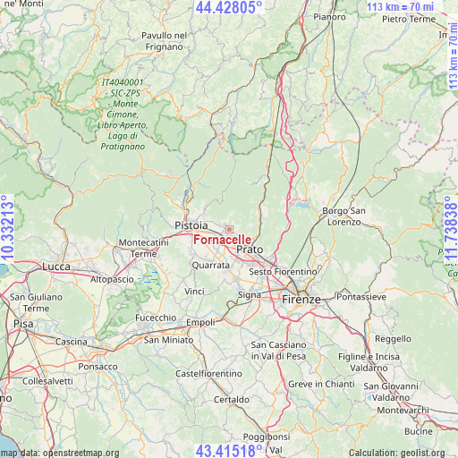
Fornacelle GPS coordinates[2]
43° 55' 25.572" North, 11° 2' 6.9" East
| Map corner | latitude | longitude |
|---|---|---|
| Upper-left | 44.42805°, | 10.33213° |
| Center: | 43.92377°, | 11.03525° |
| Lower-right: | 43.41518°, | 11.73838° |
| Map W x H: | 112.6×112.6 km | = 70×70mi |
| max Lat: | 47.04031° ⇑55.5% North |
| Fornacelle: | 43.92377° |
| min Lat: | ⇓44.5% South 35.50142° |
| min Long | Fornacelle | max Long |
| 6.69888° | 11.03525° | 18.48682° |
| W 43.2%⇐ | ⇒56.8% E |
Elevation
Elevation of Fornacelle is 68 m = 223 ft, and this is 238.7 m = 783 ft below average elevation for this country.
| Max E: |
2085 m = 6841 ft | 76.3% |
| Avg. | 306.7 m = 1006 ft | |
| Fornacelle | 68 m = 223 ft | |
Min E: |
-4 m = -13 ft | 23.7% |
See also: Italy elevation on elevation.city.
Geographical zone
Fornacelle is located in North temperate zone (between Tropic of Cancer and the Arctic Circle). Distance of this Northern Tropic circle is 2277.9 km =1415.4 mi to South.| Distance of | km | miles | from Fornacelle |
|---|---|---|---|
| North Pole | 5123.2 | 3183.4 | to North |
| Arctic Circle | 2517.3 | 1564.2 | to North |
| Tropic Cancer | 2277.9 | 1415.4 | to South |
| Equator | 4883.9 | 3034.7 | to South |


Nearby cities:
15 places around Fornacelle: (largest is in red/bold)
• Agliana
3.4 km =2.1 mi,  225°
225°
• Barba
6.6 km =4.1 mi, 226°
• Caserana
6.9 km =4.3 mi,  194°
194°
• Casini
7.8 km =4.8 mi,  201°
201°
• Fognano
3.2 km =2 mi,  0°
0°
• Montale
1.9 km =1.2 mi,  309°
309°
• Montemurlo
0.4 km =0.2 mi,  24°
24°
• Ponzano
7.4 km =4.6 mi, 308°
• Prato
6.9 km =4.3 mi,  134°
134°
• Schignano
7.3 km =4.5 mi,  51°
51°
• Stazione
2 km =1.2 mi,  238°
238°
• Tobbiana
4.5 km =2.8 mi,  7°
7°
• Vaiano
8.6 km =5.3 mi,  55°
55°
• Valenzatico
8.5 km =5.3 mi,  221°
221°
• Vignole-Olmi
7.3 km =4.5 mi,  209°
209°
Sources, notices
• [Note1] Compared only with cities in Italy existing in our database
• [Src1] Map data: © OpenStreetMap contributors (CC-BY-SA)
• [Src2] Other city data from geonames.org with taken over terms of usage.
• [Src3] Geographical zone / Annual Mean Temperature by Robert A. Rohde @ Wikipedia
