Candida geodata
Candida (Campania) is a seat of a third-order administrative division; located in Italy in Europe/Rome (GMT+2) time zone. With population of 1,026 people, there are 6557 cities with bigger population in this country. Compared to other cities in Italy, 79.3% of cities are located further ↑North; 86.1% of cities are located further ←West and 84.5% of cities have lower elevation than Candida. Note1


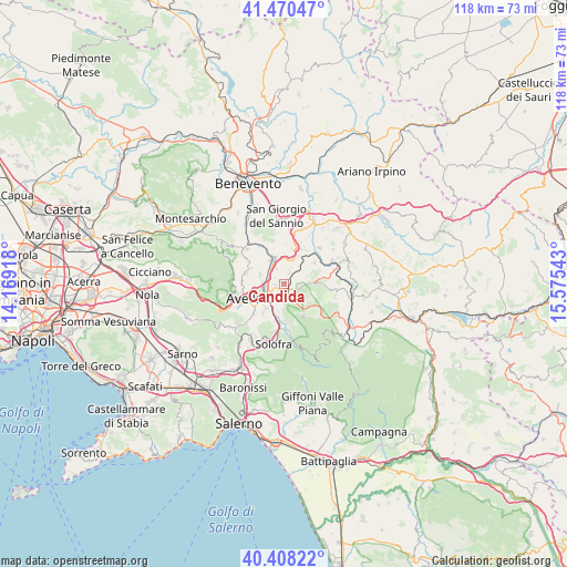
Candida GPS coordinates[2]
40° 56' 29.328" North, 14° 52' 20.28" East
| Map corner | latitude | longitude |
|---|---|---|
| Upper-left | 41.47047°, | 14.16918° |
| Center: | 40.94148°, | 14.8723° |
| Lower-right: | 40.40822°, | 15.57543° |
| Map W x H: | 118.1×118.1 km | = 73.4×73.4mi |
| max Lat: | 47.04031° ⇑79.3% North |
| Candida: | 40.94148° |
| min Lat: | ⇓20.7% South 35.50142° |
| min Long | Candida | max Long |
| 6.69888° | 14.8723° | 18.48682° |
| W 86.1%⇐ | ⇒13.9% E |
Elevation
Elevation of Candida is 601 m = 1972 ft, and this is 294.3 m = 966 ft above average elevation for this country.
| Max E: |
2085 m = 6841 ft | 15.5% |
| Candida | 601 m 1972 ft | |
| Avg. | 306.7 m = 1006 ft | |
Min E: |
-4 m = -13 ft | 84.5% |
See also: Italy elevation on elevation.city.
Geographical zone
Candida is located in North temperate zone (between Tropic of Cancer and the Arctic Circle). Distance of this Northern Tropic circle is 1946.3 km =1209.4 mi to South.| Distance of | km | miles | from Candida |
|---|---|---|---|
| North Pole | 5454.8 | 3389.5 | to North |
| Arctic Circle | 2848.9 | 1770.2 | to North |
| Tropic Cancer | 1946.3 | 1209.4 | to South |
| Equator | 4552.3 | 2828.7 | to South |


Nearby cities:
15 places around Candida: (largest is in red/bold)
• Alvanite
5.4 km =3.4 mi,  225°
225°
• Atripalda
4.6 km =2.9 mi,  236°
236°
• Cesinali
6.2 km =3.9 mi,  217°
217°
• Chiusano di San Domenico
3.8 km =2.4 mi,  104°
104°
• Manocalzati
2.1 km =1.3 mi,  270°
270°
• Montefalcione
2.4 km =1.5 mi,  21°
21°
• Montefredane
5.3 km =3.3 mi,  292°
292°
• Parolise
1.5 km =0.9 mi,  147°
147°
• Prata di Principato Ultra
5.8 km =3.6 mi,  329°
329°
• Pratola Serra
5.3 km =3.3 mi,  340°
340°
• Sabina
6.2 km =3.9 mi, 224°
• Salza Irpina
2.9 km =1.8 mi, 149°
• San Potito Ultra
1.5 km =0.9 mi,  183°
183°
• Santo Stefano del Sole
5.3 km =3.3 mi,  185°
185°
• Sorbo Serpico
3 km =1.9 mi,  155°
155°
Sources, notices
• [Note1] Compared only with cities in Italy existing in our database
• [Src1] Map data: © OpenStreetMap contributors (CC-BY-SA)
• [Src2] Other city data from geonames.org with taken over terms of usage.
• [Src3] Geographical zone / Annual Mean Temperature by Robert A. Rohde @ Wikipedia
