Montefredane geodata
Montefredane (Campania) is a seat of a third-order administrative division; located in Italy in Europe/Rome (GMT+2) time zone. With population of 948 people, there are 6870 cities with bigger population in this country. Compared to other cities in Italy, 79% of cities are located further ↑North; 85.6% of cities are located further ←West and 84.1% of cities have lower elevation than Montefredane. Note1


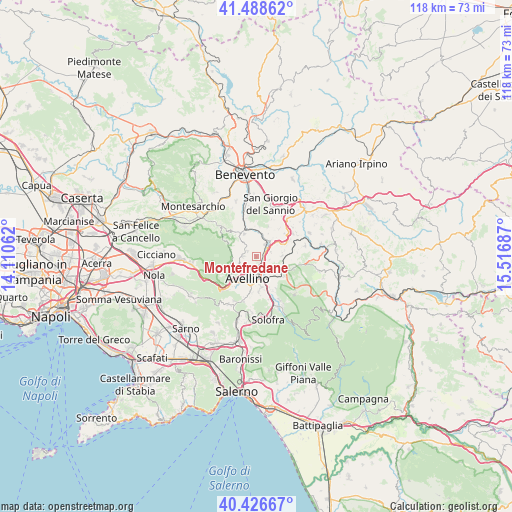
Montefredane GPS coordinates[2]
40° 57' 35.208" North, 14° 48' 49.464" East
| Map corner | latitude | longitude |
|---|---|---|
| Upper-left | 41.48862°, | 14.11062° |
| Center: | 40.95978°, | 14.81374° |
| Lower-right: | 40.42667°, | 15.51687° |
| Map W x H: | 118.1×118.1 km | = 73.4×73.4mi |
| max Lat: | 47.04031° ⇑79% North |
| Montefredane: | 40.95978° |
| min Lat: | ⇓21% South 35.50142° |
| min Long | Montefredane | max Long |
| 6.69888° | 14.81374° | 18.48682° |
| W 85.6%⇐ | ⇒14.4% E |
Elevation
Elevation of Montefredane is 594 m = 1949 ft, and this is 287.3 m = 943 ft above average elevation for this country.
| Max E: |
2085 m = 6841 ft | 15.9% |
| Montefredane | 594 m 1949 ft | |
| Avg. | 306.7 m = 1006 ft | |
Min E: |
-4 m = -13 ft | 84.1% |
See also: Italy elevation on elevation.city.
Geographical zone
Montefredane is located in North temperate zone (between Tropic of Cancer and the Arctic Circle). Distance of this Northern Tropic circle is 1948.4 km =1210.7 mi to South.| Distance of | km | miles | from Montefredane |
|---|---|---|---|
| North Pole | 5452.8 | 3388.2 | to North |
| Arctic Circle | 2846.9 | 1769 | to North |
| Tropic Cancer | 1948.4 | 1210.7 | to South |
| Equator | 4554.3 | 2829.9 | to South |


Nearby cities:
15 places around Montefredane: (largest is in red/bold)
• Altavilla Irpina
5.8 km =3.6 mi,  331°
331°
• Alvanite
5.9 km =3.7 mi,  169°
169°
• Atripalda
4.7 km =2.9 mi, 166°
• Avellino
5.3 km =3.3 mi,  200°
200°
• Candida
5.3 km =3.3 mi,  112°
112°
• Capriglia
3 km =1.9 mi,  269°
269°
• Capriglia Irpina
3.1 km =1.9 mi, 271°
• Grottolella
2.5 km =1.6 mi,  301°
301°
• Manocalzati
3.5 km =2.2 mi,  125°
125°
• Montefalcione
5.8 km =3.6 mi,  87°
87°
• Prata di Principato Ultra
3.6 km =2.2 mi,  34°
34°
• Pratola Serra
4.3 km =2.7 mi,  46°
46°
• San Potito Ultra
6 km =3.7 mi, 126°
• Summonte
5.9 km =3.7 mi,  258°
258°
• Tufo
5.9 km =3.7 mi,  3°
3°
Sources, notices
• [Note1] Compared only with cities in Italy existing in our database
• [Src1] Map data: © OpenStreetMap contributors (CC-BY-SA)
• [Src2] Other city data from geonames.org with taken over terms of usage.
• [Src3] Geographical zone / Annual Mean Temperature by Robert A. Rohde @ Wikipedia
