Campoleone geodata
Campoleone (Latium) is a populated place; located in Italy in Europe/Rome (GMT+2) time zone. With population of 1,273 people, there are 5720 cities with bigger population in this country. Compared to other cities in Italy, 73.4% of cities are located further ↑North; 64.3% of cities are located further ←West and 64.2% of cities have higher elevation than Campoleone. Note1


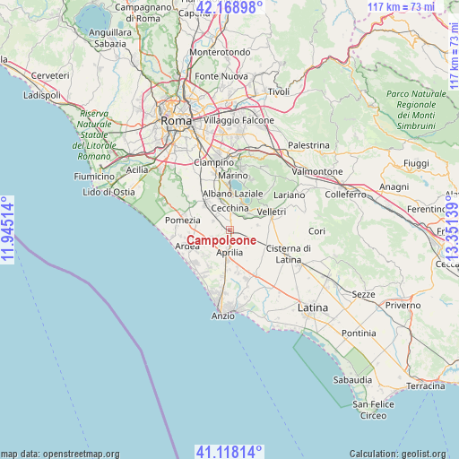
Campoleone GPS coordinates[2]
41° 38' 44.52" North, 12° 38' 53.736" East
| Map corner | latitude | longitude |
|---|---|---|
| Upper-left | 42.16898°, | 11.94514° |
| Center: | 41.6457°, | 12.64826° |
| Lower-right: | 41.11814°, | 13.35139° |
| Map W x H: | 116.8×116.8 km | = 72.6×72.6mi |
| max Lat: | 47.04031° ⇑73.4% North |
| Campoleone: | 41.6457° |
| min Lat: | ⇓26.6% South 35.50142° |
| min Long | Campoleone | max Long |
| 6.69888° | 12.64826° | 18.48682° |
| W 64.3%⇐ | ⇒35.7% E |
Elevation
Elevation of Campoleone is 133 m = 436 ft, and this is 173.7 m = 570 ft below average elevation for this country.
| Max E: |
2085 m = 6841 ft | 64.2% |
| Avg. | 306.7 m = 1006 ft | |
| Campoleone | 133 m = 436 ft | |
Min E: |
-4 m = -13 ft | 35.8% |
See also: Italy elevation on elevation.city.
Geographical zone
Campoleone is located in North temperate zone (between Tropic of Cancer and the Arctic Circle). Distance of this Northern Tropic circle is 2024.6 km =1258 mi to South.| Distance of | km | miles | from Campoleone |
|---|---|---|---|
| North Pole | 5376.5 | 3340.8 | to North |
| Arctic Circle | 2770.6 | 1721.6 | to North |
| Tropic Cancer | 2024.6 | 1258 | to South |
| Equator | 4630.6 | 2877.3 | to South |


Nearby cities:
15 places around Campoleone: (largest is in red/bold)
• Albano Laziale
9.1 km =5.7 mi,  5°
5°
• Aprilia
5.7 km =3.5 mi,  175°
175°
• Apriliana
4.3 km =2.7 mi,  232°
232°
• Ariccia
8.6 km =5.3 mi, 13°
• Bellavista
2.8 km =1.7 mi,  167°
167°
• Camilleri-Vallelata
5.8 km =3.6 mi,  206°
206°
• Cancelliera-Massimetta-Pantanelle
7.1 km =4.4 mi,  333°
333°
• Caronti
8.9 km =5.5 mi,  269°
269°
• Casalazzara
6.5 km =4 mi,  247°
247°
• Cecchina
6.2 km =3.9 mi,  1°
1°
• Colli di Cicerone
7.3 km =4.5 mi,  80°
80°
• Genzano di Roma
7.6 km =4.7 mi,  26°
26°
• Landi-Pedica
5.6 km =3.5 mi,  95°
95°
• Lanuvio
4.9 km =3 mi,  51°
51°
• Mantiglia di Ardea
4.5 km =2.8 mi,  321°
321°
Sources, notices
• [Note1] Compared only with cities in Italy existing in our database
• [Src1] Map data: © OpenStreetMap contributors (CC-BY-SA)
• [Src2] Other city data from geonames.org with taken over terms of usage.
• [Src3] Geographical zone / Annual Mean Temperature by Robert A. Rohde @ Wikipedia
