Aprilia geodata
Aprilia (Latium) is a seat of a third-order administrative division; located in Italy in Europe/Rome (GMT+2) time zone. With population of 41,094 people, there are 174 cities with bigger population in this country. Compared to other cities in Italy, 74% of cities are located further ↑North; 64.4% of cities are located further ←West and 73.8% of cities have higher elevation than Aprilia. Note1


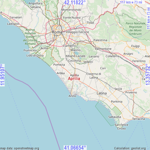
Aprilia GPS coordinates[2]
41° 35' 40.272" North, 12° 39' 15.084" East
| Map corner | latitude | longitude |
|---|---|---|
| Upper-left | 42.11822°, | 11.95107° |
| Center: | 41.59452°, | 12.65419° |
| Lower-right: | 41.06654°, | 13.35732° |
| Map W x H: | 116.9×116.9 km | = 72.6×72.6mi |
| max Lat: | 47.04031° ⇑74% North |
| Aprilia: | 41.59452° |
| min Lat: | ⇓26% South 35.50142° |
| min Long | Aprilia | max Long |
| 6.69888° | 12.65419° | 18.48682° |
| W 64.4%⇐ | ⇒35.6% E |
Elevation
Elevation of Aprilia is 79 m = 259 ft, and this is 227.7 m = 747 ft below average elevation for this country.
| Max E: |
2085 m = 6841 ft | 73.8% |
| Avg. | 306.7 m = 1006 ft | |
| Aprilia | 79 m = 259 ft | |
Min E: |
-4 m = -13 ft | 26.2% |
See also: Aprilia elevation on elevation.city.
Geographical zone
Aprilia is located in North temperate zone (between Tropic of Cancer and the Arctic Circle). Distance of this Northern Tropic circle is 2019 km =1254.5 mi to South.| Distance of | km | miles | from Aprilia |
|---|---|---|---|
| North Pole | 5382.2 | 3344.3 | to North |
| Arctic Circle | 2776.3 | 1725.1 | to North |
| Tropic Cancer | 2019 | 1254.5 | to South |
| Equator | 4624.9 | 2873.8 | to South |


Nearby cities:
15 places around Aprilia: (largest is in red/bold)
• Apriliana
5 km =3.1 mi,  308°
308°
• Ardea
9.5 km =5.9 mi,  278°
278°
• Bellavista
3 km =1.9 mi,  2°
2°
• Camilleri-Vallelata
3.1 km =1.9 mi, 278°
• Campo di Carne
4.8 km =3 mi,  193°
193°
• Campoleone
5.7 km =3.5 mi,  355°
355°
• Campoverde
9.2 km =5.7 mi,  132°
132°
• Casalazzara
7.2 km =4.5 mi,  296°
296°
• Colli di Cicerone
9.6 km =6 mi,  44°
44°
• Fossignano
7.6 km =4.7 mi,  268°
268°
• Genio Civile
6 km =3.7 mi,  148°
148°
• Landi-Pedica
7.3 km =4.5 mi, 44°
• Lanuvio
9.3 km =5.8 mi,  20°
20°
• Lido dei Pini
8.4 km =5.2 mi,  219°
219°
• Spadellata
8.5 km =5.3 mi,  204°
204°
Sources, notices
• [Note1] Compared only with cities in Italy existing in our database
• [Src1] Map data: © OpenStreetMap contributors (CC-BY-SA)
• [Src2] Other city data from geonames.org with taken over terms of usage.
• [Src3] Geographical zone / Annual Mean Temperature by Robert A. Rohde @ Wikipedia
