Campoformido geodata
Campoformido (Friuli Venezia Giulia) is a seat of a third-order administrative division; located in Italy in Europe/Rome (GMT+2) time zone. With population of 2,391 people, there are 3647 cities with bigger population in this country. Compared to other cities in Italy, 92.4% of cities are located further ↓South; 70% of cities are located further ←West and 74% of cities have higher elevation than Campoformido. Note1
Administrative division(s):
- Level 1: Friuli Venezia Giulia
- Level 2: Provincia di Udine
- Level 3: Campoformido


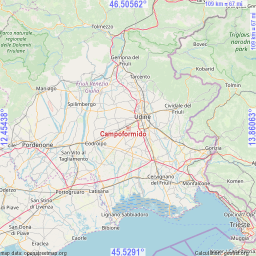
Campoformido GPS coordinates[2]
46° 1' 10.272" North, 13° 9' 27" East
| Map corner | latitude | longitude |
|---|---|---|
| Upper-left | 46.50562°, | 12.45438° |
| Center: | 46.01952°, | 13.1575° |
| Lower-right: | 45.5291°, | 13.86063° |
| Map W x H: | 108.6×108.6 km | = 67.5×67.5mi |
| max Lat: | 47.04031° ⇑7.6% North |
| Campoformido: | 46.01952° |
| min Lat: | ⇓92.4% South 35.50142° |
| min Long | Campoformido | max Long |
| 6.69888° | 13.1575° | 18.48682° |
| W 70%⇐ | ⇒30% E |
Elevation
Elevation of Campoformido is 78 m = 256 ft, and this is 228.7 m = 750 ft below average elevation for this country.
| Max E: |
2085 m = 6841 ft | 74% |
| Avg. | 306.7 m = 1006 ft | |
| Campoformido | 78 m = 256 ft | |
Min E: |
-4 m = -13 ft | 26% |
See also: Italy elevation on elevation.city.
Geographical zone
Campoformido is located in North temperate zone (between Tropic of Cancer and the Arctic Circle). Distance of this North polar circle is 2284.3 km =1419.4 mi to North.| Distance of | km | miles | from Campoformido |
|---|---|---|---|
| North Pole | 4890.2 | 3038.6 | to North |
| Arctic Circle | 2284.3 | 1419.4 | to North |
| Tropic Cancer | 2511 | 1560.3 | to South |
| Equator | 5116.9 | 3179.5 | to South |


Nearby cities:
15 places around Campoformido: (largest is in red/bold)
• Basaldella
4.7 km =2.9 mi,  82°
82°
• Basiliano-Vissandone
5 km =3.1 mi,  274°
274°
• Blessano
4.7 km =2.9 mi,  298°
298°
• Bressa
1.8 km =1.1 mi,  334°
334°
• Cargnacco
6.2 km =3.9 mi,  106°
106°
• Carpeneto
3 km =1.9 mi,  149°
149°
• Colloredo di Prato
3.7 km =2.3 mi,  343°
343°
• Nogaredo di Prato
6.5 km =4 mi, 344°
• Pasian di Prato
3.8 km =2.4 mi,  37°
37°
• Passons
6 km =3.7 mi,  24°
24°
• Pozzuolo del Friuli
4.9 km =3 mi,  141°
141°
• Santa Maria
5.5 km =3.4 mi,  177°
177°
• Sclaunicco
5.1 km =3.2 mi,  197°
197°
• Variano
3.5 km =2.2 mi,  283°
283°
• Zugliano-Terenzano-Cargnacco
4.8 km =3 mi, 106°
Sources, notices
• [Note1] Compared only with cities in Italy existing in our database
• [Src1] Map data: © OpenStreetMap contributors (CC-BY-SA)
• [Src2] Other city data from geonames.org with taken over terms of usage.
• [Src3] Geographical zone / Annual Mean Temperature by Robert A. Rohde @ Wikipedia
