Campitello geodata
Campitello (Lombardy) is a populated place; located in Italy in Europe/Rome (GMT+2) time zone. With population of 1,795 people, there are 4497 cities with bigger population in this country. Compared to other cities in Italy, 62.1% of cities are located further ↓South; 61.8% of cities are located further →East and 87% of cities have higher elevation than Campitello. Note1


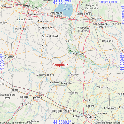
Campitello GPS coordinates[2]
45° 5' 15" North, 10° 36' 22.752" East
| Map corner | latitude | longitude |
|---|---|---|
| Upper-left | 45.58177°, | 9.90319° |
| Center: | 45.0875°, | 10.60632° |
| Lower-right: | 44.58892°, | 11.30945° |
| Map W x H: | 110.4×110.4 km | = 68.6×68.6mi |
| max Lat: | 47.04031° ⇑37.9% North |
| Campitello: | 45.0875° |
| min Lat: | ⇓62.1% South 35.50142° |
| min Long | Campitello | max Long |
| 6.69888° | 10.60632° | 18.48682° |
| W 38.2%⇐ | ⇒61.8% E |
Elevation
Elevation of Campitello is 25 m = 82 ft, and this is 281.7 m = 924 ft below average elevation for this country.
| Max E: |
2085 m = 6841 ft | 87% |
| Avg. | 306.7 m = 1006 ft | |
| Campitello | 25 m = 82 ft | |
Min E: |
-4 m = -13 ft | 13% |
See also: Italy elevation on elevation.city.
Geographical zone
Campitello is located in North temperate zone (between Tropic of Cancer and the Arctic Circle). Distance of this North polar circle is 2387.9 km =1483.8 mi to North.| Distance of | km | miles | from Campitello |
|---|---|---|---|
| North Pole | 4993.8 | 3103 | to North |
| Arctic Circle | 2387.9 | 1483.8 | to North |
| Tropic Cancer | 2407.3 | 1495.8 | to South |
| Equator | 5013.3 | 3115.1 | to South |


Nearby cities:
15 places around Campitello: (largest is in red/bold)
• Belforte
3.6 km =2.2 mi,  258°
258°
• Bozzolo
10.1 km =6.3 mi,  280°
280°
• Breda Cisoni
10.6 km =6.6 mi,  214°
214°
• Buscoldo
7.1 km =4.4 mi,  83°
83°
• Castellucchio
7.7 km =4.8 mi,  25°
25°
• Cizzolo
9.8 km =6.1 mi,  151°
151°
• Commessaggio
7.3 km =4.5 mi,  220°
220°
• Gazzuolo
3.9 km =2.4 mi, 224°
• Grazie
10.1 km =6.3 mi,  43°
43°
• Marcaria
6.9 km =4.3 mi,  303°
303°
• Montanara
10.3 km =6.4 mi,  58°
58°
• San Martino Dall'Argine
7 km =4.3 mi, 278°
• San Matteo
8 km =5 mi,  166°
166°
• San Michele in Bosco
3.9 km =2.4 mi,  314°
314°
• Spineda
8 km =5 mi,  248°
248°
Sources, notices
• [Note1] Compared only with cities in Italy existing in our database
• [Src1] Map data: © OpenStreetMap contributors (CC-BY-SA)
• [Src2] Other city data from geonames.org with taken over terms of usage.
• [Src3] Geographical zone / Annual Mean Temperature by Robert A. Rohde @ Wikipedia
