Castellucchio geodata
Castellucchio (Lombardy) is a seat of a third-order administrative division; located in Italy in Europe/Rome (GMT+2) time zone. With population of 3,326 people, there are 2820 cities with bigger population in this country. Compared to other cities in Italy, 63.8% of cities are located further ↓South; 61.4% of cities are located further →East and 86.7% of cities have higher elevation than Castellucchio. Note1


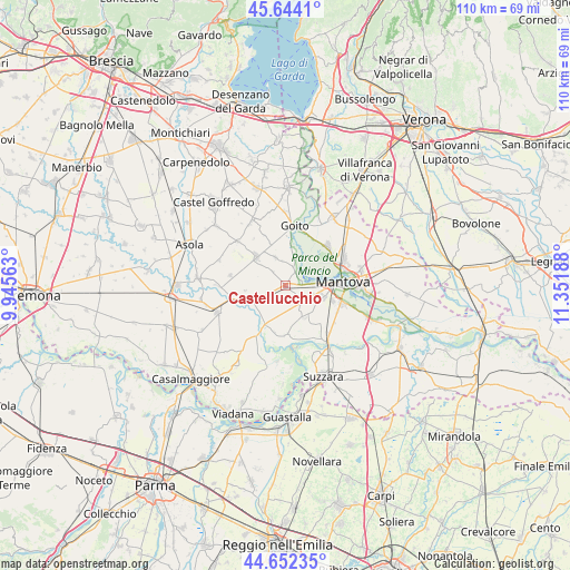
Castellucchio GPS coordinates[2]
45° 9' 1.368" North, 10° 38' 55.5" East
| Map corner | latitude | longitude |
|---|---|---|
| Upper-left | 45.6441°, | 9.94563° |
| Center: | 45.15038°, | 10.64875° |
| Lower-right: | 44.65235°, | 11.35188° |
| Map W x H: | 110.3×110.3 km | = 68.5×68.5mi |
| max Lat: | 47.04031° ⇑36.2% North |
| Castellucchio: | 45.15038° |
| min Lat: | ⇓63.8% South 35.50142° |
| min Long | Castellucchio | max Long |
| 6.69888° | 10.64875° | 18.48682° |
| W 38.6%⇐ | ⇒61.4% E |
Elevation
Elevation of Castellucchio is 26 m = 85 ft, and this is 280.7 m = 921 ft below average elevation for this country.
| Max E: |
2085 m = 6841 ft | 86.7% |
| Avg. | 306.7 m = 1006 ft | |
| Castellucchio | 26 m = 85 ft | |
Min E: |
-4 m = -13 ft | 13.3% |
See also: Italy elevation on elevation.city.
Geographical zone
Castellucchio is located in North temperate zone (between Tropic of Cancer and the Arctic Circle). Distance of this North polar circle is 2380.9 km =1479.4 mi to North.| Distance of | km | miles | from Castellucchio |
|---|---|---|---|
| North Pole | 4986.8 | 3098.7 | to North |
| Arctic Circle | 2380.9 | 1479.4 | to North |
| Tropic Cancer | 2414.3 | 1500.2 | to South |
| Equator | 5020.3 | 3119.5 | to South |


Nearby cities:
15 places around Castellucchio: (largest is in red/bold)
• Belforte
10.3 km =6.4 mi,  221°
221°
• Buscoldo
7.2 km =4.5 mi,  149°
149°
• Campitello
7.7 km =4.8 mi,  205°
205°
• Eremo
7.7 km =4.8 mi,  106°
106°
• Gazoldo degli Ippoliti
7.8 km =4.8 mi,  315°
315°
• Goito
11.2 km =7 mi,  4°
4°
• Grazie
3.6 km =2.2 mi,  83°
83°
• Levata
9.8 km =6.1 mi, 106°
• Marcaria
9.6 km =6 mi,  251°
251°
• Marmirolo
11.4 km =7.1 mi,  47°
47°
• Montanara
5.7 km =3.5 mi, 106°
• Redondesco
10.8 km =6.7 mi,  279°
279°
• Rodigo
5.7 km =3.5 mi,  341°
341°
• San Michele in Bosco
7.4 km =4.6 mi,  235°
235°
• Soave
7.7 km =4.8 mi, 49°
Sources, notices
• [Note1] Compared only with cities in Italy existing in our database
• [Src1] Map data: © OpenStreetMap contributors (CC-BY-SA)
• [Src2] Other city data from geonames.org with taken over terms of usage.
• [Src3] Geographical zone / Annual Mean Temperature by Robert A. Rohde @ Wikipedia
