Campagnano di Roma geodata
Campagnano di Roma (Latium) is a seat of a third-order administrative division; located in Italy in Europe/Rome (GMT+2) time zone. With population of 7,179 people, there are 1361 cities with bigger population in this country. Compared to other cities in Italy, 69.2% of cities are located further ↑North; 61% of cities are located further ←West and 61.1% of cities have lower elevation than Campagnano di Roma. Note1
Administrative division(s):
- Level 1: Latium
- Level 2: Città metropolitana di Roma Capitale
- Level 3: Campagnano di Roma


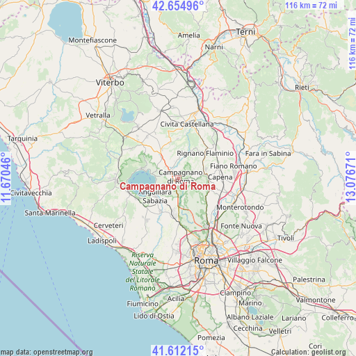
Campagnano di Roma GPS coordinates[2]
42° 8' 8.52" North, 12° 22' 24.888" East
| Map corner | latitude | longitude |
|---|---|---|
| Upper-left | 42.65496°, | 11.67046° |
| Center: | 42.1357°, | 12.37358° |
| Lower-right: | 41.61215°, | 13.07671° |
| Map W x H: | 115.9×115.9 km | = 72×72mi |
| max Lat: | 47.04031° ⇑69.2% North |
| Campagnano di Roma: | 42.1357° |
| min Lat: | ⇓30.8% South 35.50142° |
| min Long | Campagnano di R | max Long |
| 6.69888° | 12.37358° | 18.48682° |
| W 61%⇐ | ⇒39% E |
Elevation
Elevation of Campagnano di Roma is 307 m = 1007 ft, and this is 0.30000000000001 m = 1 ft above average elevation for this country.
| Max E: |
2085 m = 6841 ft | 38.9% |
| Campagnano di Roma | 307 m 1007 ft | |
| Avg. | 306.7 m = 1006 ft | |
Min E: |
-4 m = -13 ft | 61.1% |
See also: Italy elevation on elevation.city.
Geographical zone
Campagnano di Roma is located in North temperate zone (between Tropic of Cancer and the Arctic Circle). Distance of this Northern Tropic circle is 2079.1 km =1291.9 mi to South.| Distance of | km | miles | from Campagnano di Roma |
|---|---|---|---|
| North Pole | 5322 | 3306.9 | to North |
| Arctic Circle | 2716.1 | 1687.7 | to North |
| Tropic Cancer | 2079.1 | 1291.9 | to South |
| Equator | 4685.1 | 2911.2 | to South |


Nearby cities:
15 places around Campagnano di Roma: (largest is in red/bold)
• Anguillara Sabazia
9.7 km =6 mi,  229°
229°
• Belvedere Lidia
10.5 km =6.5 mi,  329°
329°
• Calcata Nuova
10.3 km =6.4 mi,  24°
24°
• Cesano
7.5 km =4.7 mi,  203°
203°
• Colle Farnese
11 km =6.8 mi, 332°
• Formello
8.3 km =5.2 mi,  168°
168°
• Le Rughe
7.4 km =4.6 mi,  178°
178°
• Magliano Romano
5.7 km =3.5 mi,  64°
64°
• Mazzano Romano
8 km =5 mi,  13°
13°
• Monte Caminetto
11.3 km =7 mi,  133°
133°
• Montelarco
9.6 km =6 mi,  71°
71°
• Monterosi
8.7 km =5.4 mi,  321°
321°
• Morlupo
10.8 km =6.7 mi,  81°
81°
• Poggio Ellera
2.4 km =1.5 mi, 183°
• Sacrofano
7 km =4.3 mi,  119°
119°
Sources, notices
• [Note1] Compared only with cities in Italy existing in our database
• [Src1] Map data: © OpenStreetMap contributors (CC-BY-SA)
• [Src2] Other city data from geonames.org with taken over terms of usage.
• [Src3] Geographical zone / Annual Mean Temperature by Robert A. Rohde @ Wikipedia
