Sacrofano geodata
Sacrofano (Latium) is a seat of a third-order administrative division; located in Italy in Europe/Rome (GMT+2) time zone. With population of 2,871 people, there are 3145 cities with bigger population in this country. Compared to other cities in Italy, 69.4% of cities are located further ↑North; 61.8% of cities are located further ←West and 53% of cities have higher elevation than Sacrofano. Note1
Administrative division(s):
- Level 1: Latium
- Level 2: Città metropolitana di Roma Capitale
- Level 3: Sacrofano


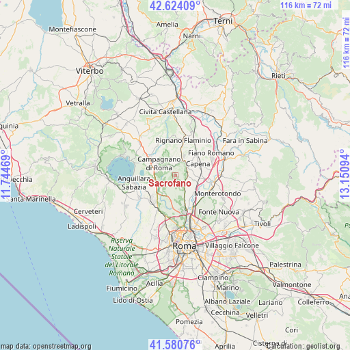
Sacrofano GPS coordinates[2]
42° 6' 16.452" North, 12° 26' 52.116" East
| Map corner | latitude | longitude |
|---|---|---|
| Upper-left | 42.62409°, | 11.74469° |
| Center: | 42.10457°, | 12.44781° |
| Lower-right: | 41.58076°, | 13.15094° |
| Map W x H: | 116×116 km | = 72.1×72.1mi |
| max Lat: | 47.04031° ⇑69.4% North |
| Sacrofano: | 42.10457° |
| min Lat: | ⇓30.6% South 35.50142° |
| min Long | Sacrofano | max Long |
| 6.69888° | 12.44781° | 18.48682° |
| W 61.8%⇐ | ⇒38.2% E |
Elevation
Elevation of Sacrofano is 216 m = 709 ft, and this is 90.7 m = 298 ft below average elevation for this country.
| Max E: |
2085 m = 6841 ft | 53% |
| Avg. | 306.7 m = 1006 ft | |
| Sacrofano | 216 m = 709 ft | |
Min E: |
-4 m = -13 ft | 47% |
See also: Italy elevation on elevation.city.
Geographical zone
Sacrofano is located in North temperate zone (between Tropic of Cancer and the Arctic Circle). Distance of this Northern Tropic circle is 2075.7 km =1289.8 mi to South.| Distance of | km | miles | from Sacrofano |
|---|---|---|---|
| North Pole | 5325.5 | 3309.1 | to North |
| Arctic Circle | 2719.6 | 1689.9 | to North |
| Tropic Cancer | 2075.7 | 1289.8 | to South |
| Equator | 4681.6 | 2909 | to South |


Nearby cities:
15 places around Sacrofano: (largest is in red/bold)
• Campagnano di Roma
7 km =4.3 mi,  299°
299°
• Capena
9.1 km =5.7 mi,  62°
62°
• Castelnuovo di Porto
5.5 km =3.4 mi,  68°
68°
• Cesano
9.8 km =6.1 mi,  249°
249°
• Colle del Fagiano
8.5 km =5.3 mi,  86°
86°
• Costaroni
7.9 km =4.9 mi,  111°
111°
• Formello
6.4 km =4 mi,  223°
223°
• Le Rughe
7.1 km =4.4 mi,  236°
236°
• Magliano Romano
6 km =3.7 mi,  351°
351°
• Monte Caminetto
4.7 km =2.9 mi,  153°
153°
• Montelarco
7.2 km =4.5 mi,  24°
24°
• Morlupo
6.8 km =4.2 mi,  42°
42°
• Poggio Ellera
6.4 km =4 mi,  279°
279°
• Riano
5.6 km =3.5 mi,  102°
102°
• Tre Pontoni
9.7 km =6 mi, 90°
Sources, notices
• [Note1] Compared only with cities in Italy existing in our database
• [Src1] Map data: © OpenStreetMap contributors (CC-BY-SA)
• [Src2] Other city data from geonames.org with taken over terms of usage.
• [Src3] Geographical zone / Annual Mean Temperature by Robert A. Rohde @ Wikipedia
