Cadè-Gaida geodata
Cadè-Gaida (Emilia-Romagna) is a populated place; located in Italy in Europe/Rome (GMT+2) time zone. With population of 2,049 people, there are 4076 cities with bigger population in this country. Compared to other cities in Italy, 55% of cities are located further ↓South; 62.7% of cities are located further →East and 79.9% of cities have higher elevation than Cadè-Gaida. Note1
Administrative division(s):
- Level 1: Emilia-Romagna
- Level 2: Provincia di Reggio Emilia
- Level 3: Reggio nell'Emilia


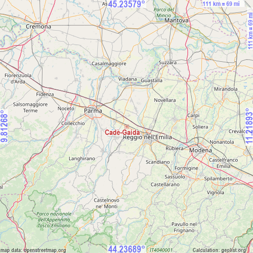
Cadè-Gaida GPS coordinates[2]
44° 44' 18.6" North, 10° 30' 56.88" East
| Map corner | latitude | longitude |
|---|---|---|
| Upper-left | 45.23579°, | 9.81268° |
| Center: | 44.7385°, | 10.5158° |
| Lower-right: | 44.23689°, | 11.21893° |
| Map W x H: | 111.1×111.1 km | = 69×69mi |
| max Lat: | 47.04031° ⇑45% North |
| Cadè-Gaida: | 44.7385° |
| min Lat: | ⇓55% South 35.50142° |
| min Long | Cadè-Gaida | max Long |
| 6.69888° | 10.5158° | 18.48682° |
| W 37.3%⇐ | ⇒62.7% E |
Elevation
Elevation of Cadè-Gaida is 50 m = 164 ft, and this is 256.7 m = 842 ft below average elevation for this country.
| Max E: |
2085 m = 6841 ft | 79.9% |
| Avg. | 306.7 m = 1006 ft | |
| Cadè-Gaida | 50 m = 164 ft | |
Min E: |
-4 m = -13 ft | 20.1% |
See also: Italy elevation on elevation.city.
Geographical zone
Cadè-Gaida is located in North temperate zone (between Tropic of Cancer and the Arctic Circle). Distance of this Northern Tropic circle is 2368.5 km =1471.7 mi to South.| Distance of | km | miles | from Cadè-Gaida |
|---|---|---|---|
| North Pole | 5032.6 | 3127.1 | to North |
| Arctic Circle | 2426.7 | 1507.9 | to North |
| Tropic Cancer | 2368.5 | 1471.7 | to South |
| Equator | 4974.5 | 3091 | to South |


Nearby cities:
15 places around Cadè-Gaida: (largest is in red/bold)
• Barco
5.8 km =3.6 mi,  195°
195°
• Cadelbosco di Sopra
7.2 km =4.5 mi,  65°
65°
• Calerno
2.6 km =1.6 mi,  295°
295°
• Campegine
4.8 km =3 mi,  11°
11°
• Caprara
4.1 km =2.5 mi,  355°
355°
• Case Cocconi
5.7 km =3.5 mi, 6°
• Cavriago
4.9 km =3 mi,  170°
170°
• Codemondo-Quaresimo
6 km =3.7 mi,  152°
152°
• Ghiardo
8.1 km =5 mi,  185°
185°
• Montecchio Emilia
6.7 km =4.2 mi,  229°
229°
• Praticello
8.1 km =5 mi,  335°
335°
• Roncocesi
4.9 km =3 mi,  90°
90°
• San Bartolomeo
7.4 km =4.6 mi, 165°
• Sant'Ilario d'Enza
5.9 km =3.7 mi,  292°
292°
• Taneto
6 km =3.7 mi,  308°
308°
Sources, notices
• [Note1] Compared only with cities in Italy existing in our database
• [Src1] Map data: © OpenStreetMap contributors (CC-BY-SA)
• [Src2] Other city data from geonames.org with taken over terms of usage.
• [Src3] Geographical zone / Annual Mean Temperature by Robert A. Rohde @ Wikipedia
