Campegine geodata
Campegine (Emilia-Romagna) is a seat of a third-order administrative division; located in Italy in Europe/Rome (GMT+2) time zone. With population of 2,527 people, there are 3498 cities with bigger population in this country. Compared to other cities in Italy, 55.8% of cities are located further ↓South; 62.5% of cities are located further →East and 83.4% of cities have higher elevation than Campegine. Note1
Administrative division(s):
- Level 1: Emilia-Romagna
- Level 2: Provincia di Reggio Emilia
- Level 3: Campegine


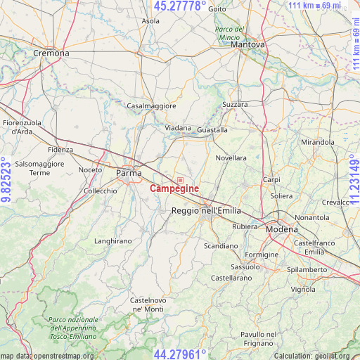
Campegine GPS coordinates[2]
44° 46' 51.06" North, 10° 31' 42.096" East
| Map corner | latitude | longitude |
|---|---|---|
| Upper-left | 45.27778°, | 9.82523° |
| Center: | 44.78085°, | 10.52836° |
| Lower-right: | 44.27961°, | 11.23149° |
| Map W x H: | 111×111 km | = 69×69mi |
| max Lat: | 47.04031° ⇑44.2% North |
| Campegine: | 44.78085° |
| min Lat: | ⇓55.8% South 35.50142° |
| min Long | Campegine | max Long |
| 6.69888° | 10.52836° | 18.48682° |
| W 37.5%⇐ | ⇒62.5% E |
Elevation
Elevation of Campegine is 36 m = 118 ft, and this is 270.7 m = 888 ft below average elevation for this country.
| Max E: |
2085 m = 6841 ft | 83.4% |
| Avg. | 306.7 m = 1006 ft | |
| Campegine | 36 m = 118 ft | |
Min E: |
-4 m = -13 ft | 16.6% |
See also: Italy elevation on elevation.city.
Geographical zone
Campegine is located in North temperate zone (between Tropic of Cancer and the Arctic Circle). Distance of this Northern Tropic circle is 2373.2 km =1474.6 mi to South.| Distance of | km | miles | from Campegine |
|---|---|---|---|
| North Pole | 5027.9 | 3124.2 | to North |
| Arctic Circle | 2422 | 1505 | to North |
| Tropic Cancer | 2373.2 | 1474.6 | to South |
| Equator | 4979.2 | 3093.9 | to South |


Nearby cities:
15 places around Campegine: (largest is in red/bold)
• Argine
8.4 km =5.2 mi,  94°
94°
• Cadelbosco di Sopra
5.8 km =3.6 mi,  106°
106°
• Cadelbosco di Sotto
7.3 km =4.5 mi,  71°
71°
• Cadè-Gaida
4.8 km =3 mi,  191°
191°
• Calerno
4.9 km =3 mi,  223°
223°
• Caprara
1.5 km =0.9 mi,  244°
244°
• Case Cocconi
1 km =0.6 mi,  339°
339°
• Castelnovo di Sotto
4.7 km =2.9 mi,  40°
40°
• Meletole
8.7 km =5.4 mi,  29°
29°
• Poviglio
6.9 km =4.3 mi,  7°
7°
• Praticello
5.1 km =3.2 mi,  300°
300°
• Praticello di Gattatico
5 km =3.1 mi, 302°
• Roncocesi
6.1 km =3.8 mi,  140°
140°
• Sant'Ilario d'Enza
6.8 km =4.2 mi,  249°
249°
• Taneto
5.8 km =3.6 mi,  260°
260°
Sources, notices
• [Note1] Compared only with cities in Italy existing in our database
• [Src1] Map data: © OpenStreetMap contributors (CC-BY-SA)
• [Src2] Other city data from geonames.org with taken over terms of usage.
• [Src3] Geographical zone / Annual Mean Temperature by Robert A. Rohde @ Wikipedia
