Brugherio geodata
Brugherio (Lombardy) is a seat of a third-order administrative division; located in Italy in Europe/Rome (GMT+2) time zone. With population of 33,061 people, there are 237 cities with bigger population in this country. Compared to other cities in Italy, 75.4% of cities are located further ↓South; 76.4% of cities are located further →East and 62% of cities have higher elevation than Brugherio. Note1
Administrative division(s):
- Level 1: Lombardy
- Level 2: Provincia di Monza e della Brianza
- Level 3: Brugherio


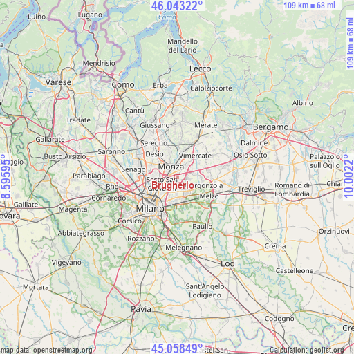
Brugherio GPS coordinates[2]
45° 33' 10.836" North, 9° 17' 56.652" East
| Map corner | latitude | longitude |
|---|---|---|
| Upper-left | 46.04322°, | 8.59595° |
| Center: | 45.55301°, | 9.29907° |
| Lower-right: | 45.05849°, | 10.0022° |
| Map W x H: | 109.5×109.5 km | = 68×68mi |
| max Lat: | 47.04031° ⇑24.6% North |
| Brugherio: | 45.55301° |
| min Lat: | ⇓75.4% South 35.50142° |
| min Long | Brugherio | max Long |
| 6.69888° | 9.29907° | 18.48682° |
| W 23.6%⇐ | ⇒76.4% E |
Elevation
Elevation of Brugherio is 149 m = 489 ft, and this is 157.7 m = 517 ft below average elevation for this country.
| Max E: |
2085 m = 6841 ft | 62% |
| Avg. | 306.7 m = 1006 ft | |
| Brugherio | 149 m = 489 ft | |
Min E: |
-4 m = -13 ft | 38% |
See also: Italy elevation on elevation.city.
Geographical zone
Brugherio is located in North temperate zone (between Tropic of Cancer and the Arctic Circle). Distance of this North polar circle is 2336.2 km =1451.6 mi to North.| Distance of | km | miles | from Brugherio |
|---|---|---|---|
| North Pole | 4942 | 3070.8 | to North |
| Arctic Circle | 2336.2 | 1451.6 | to North |
| Tropic Cancer | 2459.1 | 1528 | to South |
| Equator | 5065 | 3147.2 | to South |


Nearby cities:
15 places around Brugherio: (largest is in red/bold)
• Agrate Brianza
4.5 km =2.8 mi,  58°
58°
• Bussero
6.1 km =3.8 mi,  110°
110°
• Caponago
6.2 km =3.9 mi,  75°
75°
• Carugate
3.2 km =2 mi,  96°
96°
• Cassina de' Pecchi
6.2 km =3.9 mi,  130°
130°
• Cernusco sul Naviglio
4.1 km =2.5 mi,  139°
139°
• Cologno Monzese
3 km =1.9 mi,  212°
212°
• Concorezzo
4.8 km =3 mi,  34°
34°
• Monza
3.7 km =2.3 mi,  325°
325°
• Pessano Con Bornago
6.4 km =4 mi,  93°
93°
• Pioltello
6.2 km =3.9 mi,  156°
156°
• Ronco
5.5 km =3.4 mi,  122°
122°
• Sesto San Giovanni
6.1 km =3.8 mi,  248°
248°
• Villasanta
6 km =3.7 mi,  6°
6°
• Vimodrone
4.4 km =2.7 mi,  191°
191°
Sources, notices
• [Note1] Compared only with cities in Italy existing in our database
• [Src1] Map data: © OpenStreetMap contributors (CC-BY-SA)
• [Src2] Other city data from geonames.org with taken over terms of usage.
• [Src3] Geographical zone / Annual Mean Temperature by Robert A. Rohde @ Wikipedia
