Caponago geodata
Caponago (Lombardy) is a seat of a third-order administrative division; located in Italy in Europe/Rome (GMT+2) time zone. With population of 5,027 people, there are 1947 cities with bigger population in this country. Compared to other cities in Italy, 75.8% of cities are located further ↓South; 75% of cities are located further →East and 60.4% of cities have higher elevation than Caponago. Note1
Administrative division(s):
- Level 1: Lombardy
- Level 2: Provincia di Monza e della Brianza
- Level 3: Caponago


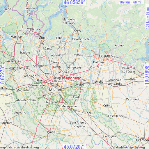
Caponago GPS coordinates[2]
45° 33' 59.292" North, 9° 22' 33.06" East
| Map corner | latitude | longitude |
|---|---|---|
| Upper-left | 46.05656°, | 8.67273° |
| Center: | 45.56647°, | 9.37585° |
| Lower-right: | 45.07207°, | 10.07898° |
| Map W x H: | 109.5×109.5 km | = 68×68mi |
| max Lat: | 47.04031° ⇑24.2% North |
| Caponago: | 45.56647° |
| min Lat: | ⇓75.8% South 35.50142° |
| min Long | Caponago | max Long |
| 6.69888° | 9.37585° | 18.48682° |
| W 25%⇐ | ⇒75% E |
Elevation
Elevation of Caponago is 160 m = 525 ft, and this is 146.7 m = 481 ft below average elevation for this country.
| Max E: |
2085 m = 6841 ft | 60.4% |
| Avg. | 306.7 m = 1006 ft | |
| Caponago | 160 m = 525 ft | |
Min E: |
-4 m = -13 ft | 39.6% |
See also: Italy elevation on elevation.city.
Geographical zone
Caponago is located in North temperate zone (between Tropic of Cancer and the Arctic Circle). Distance of this North polar circle is 2334.7 km =1450.7 mi to North.| Distance of | km | miles | from Caponago |
|---|---|---|---|
| North Pole | 4940.5 | 3069.9 | to North |
| Arctic Circle | 2334.7 | 1450.7 | to North |
| Tropic Cancer | 2460.6 | 1528.9 | to South |
| Equator | 5066.5 | 3148.2 | to South |


Nearby cities:
15 places around Caponago: (largest is in red/bold)
• Agrate Brianza
2.3 km =1.4 mi,  291°
291°
• Burago di Molgora
3.4 km =2.1 mi,  7°
7°
• Bussero
3.6 km =2.2 mi,  184°
184°
• Cambiago
4.9 km =3 mi,  71°
71°
• Carugate
3.3 km =2.1 mi,  236°
236°
• Cavenago di Brianza
3.4 km =2.1 mi,  57°
57°
• Concorezzo
4.1 km =2.5 mi,  306°
306°
• Gessate
5.2 km =3.2 mi,  112°
112°
• Gorgonzola
4.6 km =2.9 mi,  150°
150°
• Ornago
5.1 km =3.2 mi,  43°
43°
• Pessano Con Bornago
2 km =1.2 mi,  167°
167°
• Ronco
4.6 km =2.9 mi,  196°
196°
• Sant'Agata Martesana
5 km =3.1 mi, 172°
• Torrazza dei Mandelli
1.8 km =1.1 mi,  90°
90°
• Vimercate
5.5 km =3.4 mi,  353°
353°
Sources, notices
• [Note1] Compared only with cities in Italy existing in our database
• [Src1] Map data: © OpenStreetMap contributors (CC-BY-SA)
• [Src2] Other city data from geonames.org with taken over terms of usage.
• [Src3] Geographical zone / Annual Mean Temperature by Robert A. Rohde @ Wikipedia
