Brufa geodata
Brufa (Umbria) is a populated place; located in Italy in Europe/Rome (GMT+2) time zone. With population of 956 people, there are 6840 cities with bigger population in this country. Compared to other cities in Italy, 62.9% of cities are located further ↑North; 62% of cities are located further ←West and 57.7% of cities have lower elevation than Brufa. Note1


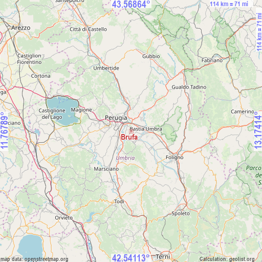
Brufa GPS coordinates[2]
43° 3' 25.344" North, 12° 28' 15.636" East
| Map corner | latitude | longitude |
|---|---|---|
| Upper-left | 43.56864°, | 11.76789° |
| Center: | 43.05704°, | 12.47101° |
| Lower-right: | 42.54113°, | 13.17414° |
| Map W x H: | 114.2×114.2 km | = 71×71mi |
| max Lat: | 47.04031° ⇑62.9% North |
| Brufa: | 43.05704° |
| min Lat: | ⇓37.1% South 35.50142° |
| min Long | Brufa | max Long |
| 6.69888° | 12.47101° | 18.48682° |
| W 62%⇐ | ⇒38% E |
Elevation
Elevation of Brufa is 284 m = 932 ft, and this is 22.7 m = 74 ft below average elevation for this country.
| Max E: |
2085 m = 6841 ft | 42.3% |
| Avg. | 306.7 m = 1006 ft | |
| Brufa | 284 m = 932 ft | |
Min E: |
-4 m = -13 ft | 57.7% |
See also: Italy elevation on elevation.city.
Geographical zone
Brufa is located in North temperate zone (between Tropic of Cancer and the Arctic Circle). Distance of this Northern Tropic circle is 2181.6 km =1355.6 mi to South.| Distance of | km | miles | from Brufa |
|---|---|---|---|
| North Pole | 5219.6 | 3243.3 | to North |
| Arctic Circle | 2613.7 | 1624.1 | to North |
| Tropic Cancer | 2181.6 | 1355.6 | to South |
| Equator | 4787.5 | 2974.8 | to South |


Nearby cities:
15 places around Brufa: (largest is in red/bold)
• Bastia umbra
6.2 km =3.9 mi,  82°
82°
• Bettona
5.3 km =3.3 mi,  165°
165°
• Costano
5.3 km =3.3 mi,  105°
105°
• Fornaci
6 km =3.7 mi,  223°
223°
• Ospedalicchio
3.4 km =2.1 mi,  45°
45°
• Passaggio
4.9 km =3 mi,  142°
142°
• Petrignano
7.1 km =4.4 mi,  44°
44°
• Ponte Nuovo
6.8 km =4.2 mi,  210°
210°
• San Martino in Campo
6 km =3.7 mi,  247°
247°
• San Niccolò di Celle
8.4 km =5.2 mi,  237°
237°
• Sant'Egidio
5.3 km =3.3 mi,  17°
17°
• Santa Maria degli Angeli
8.4 km =5.2 mi,  90°
90°
• Tordandrea
7.3 km =4.5 mi, 108°
• Torgiano
4.1 km =2.5 mi, 217°
• Via Lippia
3.3 km =2.1 mi,  14°
14°
Sources, notices
• [Note1] Compared only with cities in Italy existing in our database
• [Src1] Map data: © OpenStreetMap contributors (CC-BY-SA)
• [Src2] Other city data from geonames.org with taken over terms of usage.
• [Src3] Geographical zone / Annual Mean Temperature by Robert A. Rohde @ Wikipedia
