Petrignano geodata
Petrignano (Umbria) is a populated place; located in Italy in Europe/Rome (GMT+2) time zone. With population of 3,184 people, there are 2904 cities with bigger population in this country. Compared to other cities in Italy, 62.6% of cities are located further ↑North; 62.7% of cities are located further ←West and 53.8% of cities have higher elevation than Petrignano. Note1


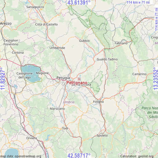
Petrignano GPS coordinates[2]
43° 6' 9.684" North, 12° 31' 56.604" East
| Map corner | latitude | longitude |
|---|---|---|
| Upper-left | 43.61391°, | 11.82927° |
| Center: | 43.10269°, | 12.53239° |
| Lower-right: | 42.58717°, | 13.23552° |
| Map W x H: | 114.2×114.2 km | = 71×71mi |
| max Lat: | 47.04031° ⇑62.6% North |
| Petrignano: | 43.10269° |
| min Lat: | ⇓37.4% South 35.50142° |
| min Long | Petrignano | max Long |
| 6.69888° | 12.53239° | 18.48682° |
| W 62.7%⇐ | ⇒37.3% E |
Elevation
Elevation of Petrignano is 211 m = 692 ft, and this is 95.7 m = 314 ft below average elevation for this country.
| Max E: |
2085 m = 6841 ft | 53.8% |
| Avg. | 306.7 m = 1006 ft | |
| Petrignano | 211 m = 692 ft | |
Min E: |
-4 m = -13 ft | 46.2% |
See also: Italy elevation on elevation.city.
Geographical zone
Petrignano is located in North temperate zone (between Tropic of Cancer and the Arctic Circle). Distance of this Northern Tropic circle is 2186.7 km =1358.8 mi to South.| Distance of | km | miles | from Petrignano |
|---|---|---|---|
| North Pole | 5214.5 | 3240.1 | to North |
| Arctic Circle | 2608.6 | 1620.9 | to North |
| Tropic Cancer | 2186.7 | 1358.8 | to South |
| Equator | 4792.6 | 2978 | to South |


Nearby cities:
15 places around Petrignano: (largest is in red/bold)
• Assisi
8.2 km =5.1 mi,  119°
119°
• Bastia umbra
4.4 km =2.7 mi,  165°
165°
• Brufa
7.1 km =4.4 mi,  224°
224°
• Colombella
6.9 km =4.3 mi,  323°
323°
• Costano
6.5 km =4 mi,  178°
178°
• Ospedalicchio
3.8 km =2.4 mi, 223°
• Palazzo
2.7 km =1.7 mi,  103°
103°
• Piccione
8.8 km =5.5 mi,  347°
347°
• Ponte Felcino
7.4 km =4.6 mi,  294°
294°
• Sant'Egidio
3.4 km =2.1 mi,  269°
269°
• Santa Maria degli Angeli
6.2 km =3.9 mi,  145°
145°
• Torchiagina
1.9 km =1.2 mi,  5°
5°
• Tordandrea
7.7 km =4.8 mi, 165°
• Valfabbrica
8.3 km =5.2 mi,  42°
42°
• Via Lippia
4.6 km =2.9 mi,  246°
246°
Sources, notices
• [Note1] Compared only with cities in Italy existing in our database
• [Src1] Map data: © OpenStreetMap contributors (CC-BY-SA)
• [Src2] Other city data from geonames.org with taken over terms of usage.
• [Src3] Geographical zone / Annual Mean Temperature by Robert A. Rohde @ Wikipedia
