Fornaci geodata
Fornaci (Umbria) is a populated place; located in Italy in Europe/Rome (GMT+2) time zone. With population of 763 people, there are 7862 cities with bigger population in this country. Compared to other cities in Italy, 63.3% of cities are located further ↑North; 61.5% of cities are located further ←West and 59% of cities have higher elevation than Fornaci. Note1


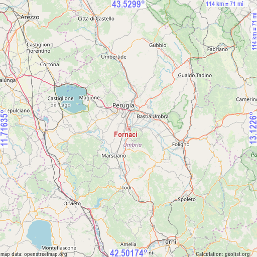
Fornaci GPS coordinates[2]
43° 1' 4.692" North, 12° 25' 10.092" East
| Map corner | latitude | longitude |
|---|---|---|
| Upper-left | 43.5299°, | 11.71635° |
| Center: | 43.01797°, | 12.41947° |
| Lower-right: | 42.50174°, | 13.1226° |
| Map W x H: | 114.3×114.3 km | = 71×71mi |
| max Lat: | 47.04031° ⇑63.3% North |
| Fornaci: | 43.01797° |
| min Lat: | ⇓36.7% South 35.50142° |
| min Long | Fornaci | max Long |
| 6.69888° | 12.41947° | 18.48682° |
| W 61.5%⇐ | ⇒38.5% E |
Elevation
Elevation of Fornaci is 171 m = 561 ft, and this is 135.7 m = 445 ft below average elevation for this country.
| Max E: |
2085 m = 6841 ft | 59% |
| Avg. | 306.7 m = 1006 ft | |
| Fornaci | 171 m = 561 ft | |
Min E: |
-4 m = -13 ft | 41% |
See also: Italy elevation on elevation.city.
Geographical zone
Fornaci is located in North temperate zone (between Tropic of Cancer and the Arctic Circle). Distance of this Northern Tropic circle is 2177.2 km =1352.8 mi to South.| Distance of | km | miles | from Fornaci |
|---|---|---|---|
| North Pole | 5223.9 | 3246 | to North |
| Arctic Circle | 2618 | 1626.7 | to North |
| Tropic Cancer | 2177.2 | 1352.8 | to South |
| Equator | 4783.1 | 2972.1 | to South |


Nearby cities:
15 places around Fornaci: (largest is in red/bold)
• Bettona
5.5 km =3.4 mi,  97°
97°
• Brufa
6 km =3.7 mi,  43°
43°
• Costano
9.8 km =6.1 mi,  72°
72°
• Deruta
3.7 km =2.3 mi,  182°
182°
• Ospedalicchio
9.4 km =5.8 mi, 44°
• Passaggio
7.2 km =4.5 mi,  86°
86°
• Pila
8.4 km =5.2 mi,  297°
297°
• Ponte Nuovo
1.7 km =1.1 mi,  154°
154°
• Ripabianca
8.8 km =5.5 mi,  188°
188°
• San Martino in Campo
2.4 km =1.5 mi,  325°
325°
• San Niccolò di Celle
2.9 km =1.8 mi,  267°
267°
• Sant'Angelo di Celle
3.6 km =2.2 mi,  231°
231°
• Sant'Enea
5.1 km =3.2 mi,  260°
260°
• Torgiano
2 km =1.2 mi,  57°
57°
• Via Lippia
9.1 km =5.7 mi,  33°
33°
Sources, notices
• [Note1] Compared only with cities in Italy existing in our database
• [Src1] Map data: © OpenStreetMap contributors (CC-BY-SA)
• [Src2] Other city data from geonames.org with taken over terms of usage.
• [Src3] Geographical zone / Annual Mean Temperature by Robert A. Rohde @ Wikipedia
