Borgo San Lorenzo geodata
Borgo San Lorenzo (Tuscany) is a seat of a third-order administrative division; located in Italy in Europe/Rome (GMT+2) time zone. With population of 9,716 people, there are 975 cities with bigger population in this country. Compared to other cities in Italy, 55.1% of cities are located further ↑North; 52.1% of cities are located further →East and 56.3% of cities have higher elevation than Borgo San Lorenzo. Note1
Administrative division(s):
- Level 1: Tuscany
- Level 2: Province of Florence
- Level 3: Borgo San Lorenzo


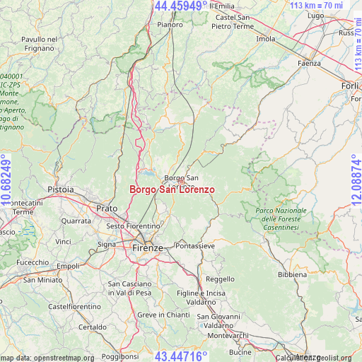
Borgo San Lorenzo GPS coordinates[2]
43° 57' 19.728" North, 11° 23' 8.196" East
| Map corner | latitude | longitude |
|---|---|---|
| Upper-left | 44.45949°, | 10.68249° |
| Center: | 43.95548°, | 11.38561° |
| Lower-right: | 43.44716°, | 12.08874° |
| Map W x H: | 112.6×112.6 km | = 70×70mi |
| max Lat: | 47.04031° ⇑55.1% North |
| Borgo San Lorenzo: | 43.95548° |
| min Lat: | ⇓44.9% South 35.50142° |
| min Long | Borgo San Loren | max Long |
| 6.69888° | 11.38561° | 18.48682° |
| W 47.9%⇐ | ⇒52.1% E |
Elevation
Elevation of Borgo San Lorenzo is 193 m = 633 ft, and this is 113.7 m = 373 ft below average elevation for this country.
| Max E: |
2085 m = 6841 ft | 56.3% |
| Avg. | 306.7 m = 1006 ft | |
| Borgo San Lorenzo | 193 m = 633 ft | |
Min E: |
-4 m = -13 ft | 43.7% |
See also: Italy elevation on elevation.city.
Geographical zone
Borgo San Lorenzo is located in North temperate zone (between Tropic of Cancer and the Arctic Circle). Distance of this Northern Tropic circle is 2281.5 km =1417.7 mi to South.| Distance of | km | miles | from Borgo San Lorenzo |
|---|---|---|---|
| North Pole | 5119.7 | 3181.2 | to North |
| Arctic Circle | 2513.8 | 1562 | to North |
| Tropic Cancer | 2281.5 | 1417.7 | to South |
| Equator | 4887.4 | 3036.9 | to South |


Nearby cities:
15 places around Borgo San Lorenzo: (largest is in red/bold)
• Barberino di Mugello
12.9 km =8 mi,  292°
292°
• Bivigliano
8.4 km =5.2 mi,  217°
217°
• Cavallina
12.7 km =7.9 mi,  284°
284°
• Galliano
10.1 km =6.3 mi,  312°
312°
• Luco Mugello
5.1 km =3.2 mi,  9°
9°
• Panicaglia
3.7 km =2.3 mi,  28°
28°
• Pratolino
12.5 km =7.8 mi,  213°
213°
• Rabatta
2.5 km =1.6 mi,  120°
120°
• Ronta
6.3 km =3.9 mi, 33°
• San Piero a Sieve
5 km =3.1 mi, 279°
• Sant'Agata
8 km =5 mi,  328°
328°
• Santa Brigida
11.6 km =7.2 mi,  175°
175°
• Scarperia
4.9 km =3 mi, 329°
• Vaglia
9.8 km =6.1 mi,  239°
239°
• Vicchio
6.4 km =4 mi,  111°
111°
Sources, notices
• [Note1] Compared only with cities in Italy existing in our database
• [Src1] Map data: © OpenStreetMap contributors (CC-BY-SA)
• [Src2] Other city data from geonames.org with taken over terms of usage.
• [Src3] Geographical zone / Annual Mean Temperature by Robert A. Rohde @ Wikipedia
