Vaglia geodata
Vaglia (Tuscany) is a seat of a third-order administrative division; located in Italy in Europe/Rome (GMT+2) time zone. With population of 885 people, there are 7236 cities with bigger population in this country. Compared to other cities in Italy, 55.6% of cities are located further ↑North; 53.4% of cities are located further →East and 57.3% of cities have lower elevation than Vaglia. Note1


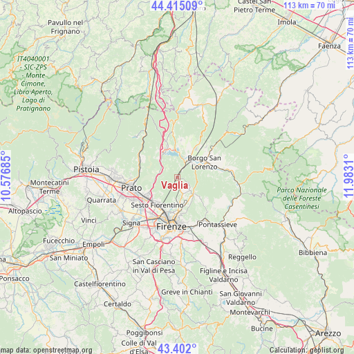
Vaglia GPS coordinates[2]
43° 54' 38.52" North, 11° 16' 47.892" East
| Map corner | latitude | longitude |
|---|---|---|
| Upper-left | 44.41509°, | 10.57685° |
| Center: | 43.9107°, | 11.27997° |
| Lower-right: | 43.402°, | 11.9831° |
| Map W x H: | 112.6×112.6 km | = 70×70mi |
| max Lat: | 47.04031° ⇑55.6% North |
| Vaglia: | 43.9107° |
| min Lat: | ⇓44.4% South 35.50142° |
| min Long | Vaglia | max Long |
| 6.69888° | 11.27997° | 18.48682° |
| W 46.6%⇐ | ⇒53.4% E |
Elevation
Elevation of Vaglia is 281 m = 922 ft, and this is 25.7 m = 84 ft below average elevation for this country.
| Max E: |
2085 m = 6841 ft | 42.7% |
| Avg. | 306.7 m = 1006 ft | |
| Vaglia | 281 m = 922 ft | |
Min E: |
-4 m = -13 ft | 57.3% |
See also: Italy elevation on elevation.city.
Geographical zone
Vaglia is located in North temperate zone (between Tropic of Cancer and the Arctic Circle). Distance of this Northern Tropic circle is 2276.5 km =1414.6 mi to South.| Distance of | km | miles | from Vaglia |
|---|---|---|---|
| North Pole | 5124.6 | 3184.3 | to North |
| Arctic Circle | 2518.8 | 1565.1 | to North |
| Tropic Cancer | 2276.5 | 1414.6 | to South |
| Equator | 4882.4 | 3033.8 | to South |


Nearby cities:
15 places around Vaglia: (largest is in red/bold)
• Barberino di Mugello
10.4 km =6.5 mi,  340°
340°
• Bivigliano
3.7 km =2.3 mi,  116°
116°
• Borgo San Lorenzo
9.8 km =6.1 mi,  59°
59°
• Caldine
9.4 km =5.8 mi,  167°
167°
• Calenzano
11.1 km =6.9 mi,  235°
235°
• Carraia
8 km =5 mi,  257°
257°
• Cavallina
9 km =5.6 mi,  334°
334°
• Pian di Mugnone
10.4 km =6.5 mi, 172°
• Pian di San Bartolo-Trespiano
8.5 km =5.3 mi,  175°
175°
• Pratolino
5.6 km =3.5 mi,  164°
164°
• Rabatta
11.3 km =7 mi,  70°
70°
• San Piero a Sieve
6.8 km =4.2 mi,  31°
31°
• Santa Brigida
11.5 km =7.1 mi,  125°
125°
• Scarperia
11 km =6.8 mi, 32°
• Sesto Fiorentino
10.9 km =6.8 mi,  216°
216°
Sources, notices
• [Note1] Compared only with cities in Italy existing in our database
• [Src1] Map data: © OpenStreetMap contributors (CC-BY-SA)
• [Src2] Other city data from geonames.org with taken over terms of usage.
• [Src3] Geographical zone / Annual Mean Temperature by Robert A. Rohde @ Wikipedia
