San Piero a Sieve geodata
San Piero a Sieve (Tuscany) is a seat of a third-order administrative division; located in Italy in Europe/Rome (GMT+2) time zone. With population of 2,951 people, there are 3081 cities with bigger population in this country. Compared to other cities in Italy, 55.1% of cities are located further ↑North; 52.8% of cities are located further →East and 53.2% of cities have higher elevation than San Piero a Sieve. Note1
Administrative division(s):
- Level 1: Tuscany
- Level 2: Province of Florence
- Level 3: Scarperia e San Piero


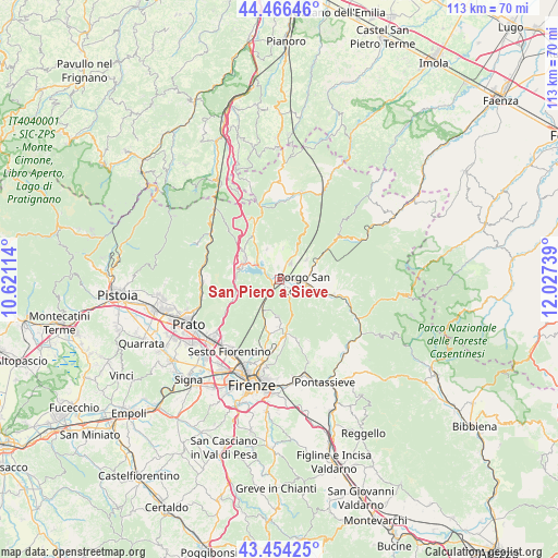
San Piero a Sieve GPS coordinates[2]
43° 57' 45.036" North, 11° 19' 27.336" East
| Map corner | latitude | longitude |
|---|---|---|
| Upper-left | 44.46646°, | 10.62114° |
| Center: | 43.96251°, | 11.32426° |
| Lower-right: | 43.45425°, | 12.02739° |
| Map W x H: | 112.5×112.5 km | = 69.9×69.9mi |
| max Lat: | 47.04031° ⇑55.1% North |
| San Piero a Sieve: | 43.96251° |
| min Lat: | ⇓44.9% South 35.50142° |
| min Long | San Piero a Sie | max Long |
| 6.69888° | 11.32426° | 18.48682° |
| W 47.2%⇐ | ⇒52.8% E |
Elevation
Elevation of San Piero a Sieve is 215 m = 705 ft, and this is 91.7 m = 301 ft below average elevation for this country.
| Max E: |
2085 m = 6841 ft | 53.2% |
| Avg. | 306.7 m = 1006 ft | |
| San Piero a Sieve | 215 m = 705 ft | |
Min E: |
-4 m = -13 ft | 46.8% |
See also: Italy elevation on elevation.city.
Geographical zone
San Piero a Sieve is located in North temperate zone (between Tropic of Cancer and the Arctic Circle). Distance of this Northern Tropic circle is 2282.3 km =1418.2 mi to South.| Distance of | km | miles | from San Piero a Sieve |
|---|---|---|---|
| North Pole | 5118.9 | 3180.7 | to North |
| Arctic Circle | 2513 | 1561.5 | to North |
| Tropic Cancer | 2282.3 | 1418.2 | to South |
| Equator | 4888.2 | 3037.4 | to South |


Nearby cities:
15 places around San Piero a Sieve: (largest is in red/bold)
• Barberino di Mugello
8.1 km =5 mi,  300°
300°
• Bivigliano
7.4 km =4.6 mi,  182°
182°
• Borgo San Lorenzo
5 km =3.1 mi,  99°
99°
• Carraia
13.6 km =8.5 mi,  236°
236°
• Cavallina
7.8 km =4.8 mi,  287°
287°
• Galliano
6.6 km =4.1 mi,  338°
338°
• Luco Mugello
7.1 km =4.4 mi,  53°
53°
• Panicaglia
7.1 km =4.4 mi,  69°
69°
• Pratolino
11.3 km =7 mi,  190°
190°
• Rabatta
7.4 km =4.6 mi,  106°
106°
• Ronta
9.5 km =5.9 mi,  61°
61°
• Sant'Agata
6.1 km =3.8 mi,  6°
6°
• Scarperia
4.2 km =2.6 mi,  34°
34°
• Vaglia
6.8 km =4.2 mi,  211°
211°
• Vicchio
11.3 km =7 mi, 106°
Sources, notices
• [Note1] Compared only with cities in Italy existing in our database
• [Src1] Map data: © OpenStreetMap contributors (CC-BY-SA)
• [Src2] Other city data from geonames.org with taken over terms of usage.
• [Src3] Geographical zone / Annual Mean Temperature by Robert A. Rohde @ Wikipedia
