Bellegra geodata
Bellegra (Latium) is a seat of a third-order administrative division; located in Italy in Europe/Rome (GMT+2) time zone. With population of 1,929 people, there are 4276 cities with bigger population in this country. Compared to other cities in Italy, 71.4% of cities are located further ↑North; 68.6% of cities are located further ←West and 91.2% of cities have lower elevation than Bellegra. Note1
Administrative division(s):
- Level 1: Latium
- Level 2: Città metropolitana di Roma Capitale
- Level 3: Bellegra


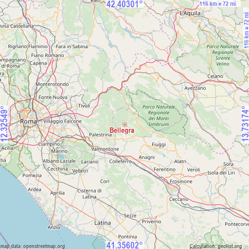
Bellegra GPS coordinates[2]
41° 52' 53.976" North, 13° 1' 42.996" East
| Map corner | latitude | longitude |
|---|---|---|
| Upper-left | 42.40301°, | 12.32549° |
| Center: | 41.88166°, | 13.02861° |
| Lower-right: | 41.35602°, | 13.73174° |
| Map W x H: | 116.4×116.4 km | = 72.3×72.3mi |
| max Lat: | 47.04031° ⇑71.4% North |
| Bellegra: | 41.88166° |
| min Lat: | ⇓28.6% South 35.50142° |
| min Long | Bellegra | max Long |
| 6.69888° | 13.02861° | 18.48682° |
| W 68.6%⇐ | ⇒31.4% E |
Elevation
Elevation of Bellegra is 748 m = 2454 ft, and this is 441.3 m = 1448 ft above average elevation for this country.
| Max E: |
2085 m = 6841 ft | 8.8% |
| Bellegra | 748 m 2454 ft | |
| Avg. | 306.7 m = 1006 ft | |
Min E: |
-4 m = -13 ft | 91.2% |
See also: Italy elevation on elevation.city.
Geographical zone
Bellegra is located in North temperate zone (between Tropic of Cancer and the Arctic Circle). Distance of this Northern Tropic circle is 2050.9 km =1274.4 mi to South.| Distance of | km | miles | from Bellegra |
|---|---|---|---|
| North Pole | 5350.3 | 3324.5 | to North |
| Arctic Circle | 2744.4 | 1705.3 | to North |
| Tropic Cancer | 2050.9 | 1274.4 | to South |
| Equator | 4656.8 | 2893.6 | to South |


Nearby cities:
15 places around Bellegra: (largest is in red/bold)
• Affile
5.8 km =3.6 mi,  87°
87°
• Arcinazzo Romano
7.1 km =4.4 mi, 91°
• Canterano
6.9 km =4.3 mi,  6°
6°
• Capranica Prenestina
6.8 km =4.2 mi,  252°
252°
• Cerreto Laziale
7.9 km =4.9 mi,  330°
330°
• Genazzano
7.6 km =4.7 mi,  218°
218°
• Gerano
6.7 km =4.2 mi, 331°
• La Forma
7.4 km =4.6 mi,  135°
135°
• Olevano Romano
2.6 km =1.6 mi,  166°
166°
• Pisoniano
6.5 km =4 mi,  296°
296°
• Rocca Santo Stefano
3.2 km =2 mi,  352°
352°
• Roiate
3.3 km =2.1 mi,  106°
106°
• San Vito Romano
4.2 km =2.6 mi,  267°
267°
• Serrone
7.1 km =4.4 mi,  128°
128°
• Subiaco
7 km =4.3 mi,  45°
45°
Sources, notices
• [Note1] Compared only with cities in Italy existing in our database
• [Src1] Map data: © OpenStreetMap contributors (CC-BY-SA)
• [Src2] Other city data from geonames.org with taken over terms of usage.
• [Src3] Geographical zone / Annual Mean Temperature by Robert A. Rohde @ Wikipedia
