Serrone geodata
Serrone (Latium) is a seat of a third-order administrative division; located in Italy in Europe/Rome (GMT+2) time zone. With population of 658 people, there are 8573 cities with bigger population in this country. Compared to other cities in Italy, 71.7% of cities are located further ↑North; 69.4% of cities are located further ←West and 88.8% of cities have lower elevation than Serrone. Note1


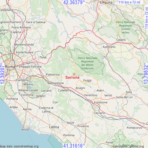
Serrone GPS coordinates[2]
41° 50' 31.632" North, 13° 5' 42.684" East
| Map corner | latitude | longitude |
|---|---|---|
| Upper-left | 42.36379°, | 12.39207° |
| Center: | 41.84212°, | 13.09519° |
| Lower-right: | 41.31616°, | 13.79832° |
| Map W x H: | 116.5×116.5 km | = 72.4×72.4mi |
| max Lat: | 47.04031° ⇑71.7% North |
| Serrone: | 41.84212° |
| min Lat: | ⇓28.3% South 35.50142° |
| min Long | Serrone | max Long |
| 6.69888° | 13.09519° | 18.48682° |
| W 69.4%⇐ | ⇒30.6% E |
Elevation
Elevation of Serrone is 689 m = 2260 ft, and this is 382.3 m = 1254 ft above average elevation for this country.
| Max E: |
2085 m = 6841 ft | 11.2% |
| Serrone | 689 m 2260 ft | |
| Avg. | 306.7 m = 1006 ft | |
Min E: |
-4 m = -13 ft | 88.8% |
See also: Italy elevation on elevation.city.
Geographical zone
Serrone is located in North temperate zone (between Tropic of Cancer and the Arctic Circle). Distance of this Northern Tropic circle is 2046.5 km =1271.6 mi to South.| Distance of | km | miles | from Serrone |
|---|---|---|---|
| North Pole | 5354.7 | 3327.3 | to North |
| Arctic Circle | 2748.8 | 1708 | to North |
| Tropic Cancer | 2046.5 | 1271.6 | to South |
| Equator | 4652.4 | 2890.9 | to South |


Nearby cities:
15 places around Serrone: (largest is in red/bold)
• Acuto
8.7 km =5.4 mi,  130°
130°
• Affile
4.7 km =2.9 mi,  3°
3°
• Arcinazzo Romano
4.5 km =2.8 mi,  20°
20°
• Bellegra
7.1 km =4.4 mi,  308°
308°
• Fiuggi
11.7 km =7.3 mi,  114°
114°
• Genazzano
10.3 km =6.4 mi,  261°
261°
• Jenne
8.1 km =5 mi,  49°
49°
• La Forma
0.9 km =0.6 mi,  202°
202°
• Olevano Romano
5.2 km =3.2 mi,  290°
290°
• Paliano
7.1 km =4.4 mi,  192°
192°
• Piglio
3.4 km =2.1 mi, 113°
• Rocca Santo Stefano
9.6 km =6 mi,  322°
322°
• Roiate
4.2 km =2.6 mi,  325°
325°
• San Vito Romano
10.6 km =6.6 mi, 293°
• Subiaco
9.4 km =5.8 mi,  356°
356°
Sources, notices
• [Note1] Compared only with cities in Italy existing in our database
• [Src1] Map data: © OpenStreetMap contributors (CC-BY-SA)
• [Src2] Other city data from geonames.org with taken over terms of usage.
• [Src3] Geographical zone / Annual Mean Temperature by Robert A. Rohde @ Wikipedia
