La Forma geodata
La Forma (Latium) is a populated place; located in Italy in Europe/Rome (GMT+2) time zone. With population of 1,515 people, there are 5084 cities with bigger population in this country. Compared to other cities in Italy, 71.7% of cities are located further ↑North; 69.3% of cities are located further ←West and 71.6% of cities have lower elevation than La Forma. Note1


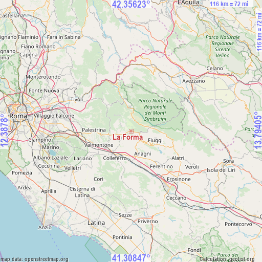
La Forma GPS coordinates[2]
41° 50' 4.164" North, 13° 5' 27.312" East
| Map corner | latitude | longitude |
|---|---|---|
| Upper-left | 42.35623°, | 12.3878° |
| Center: | 41.83449°, | 13.09092° |
| Lower-right: | 41.30847°, | 13.79405° |
| Map W x H: | 116.5×116.5 km | = 72.4×72.4mi |
| max Lat: | 47.04031° ⇑71.7% North |
| La Forma: | 41.83449° |
| min Lat: | ⇓28.3% South 35.50142° |
| min Long | La Forma | max Long |
| 6.69888° | 13.09092° | 18.48682° |
| W 69.3%⇐ | ⇒30.7% E |
Elevation
Elevation of La Forma is 411 m = 1348 ft, and this is 104.3 m = 342 ft above average elevation for this country.
| Max E: |
2085 m = 6841 ft | 28.4% |
| La Forma | 411 m 1348 ft | |
| Avg. | 306.7 m = 1006 ft | |
Min E: |
-4 m = -13 ft | 71.6% |
See also: Italy elevation on elevation.city.
Geographical zone
La Forma is located in North temperate zone (between Tropic of Cancer and the Arctic Circle). Distance of this Northern Tropic circle is 2045.6 km =1271.1 mi to South.| Distance of | km | miles | from La Forma |
|---|---|---|---|
| North Pole | 5355.5 | 3327.8 | to North |
| Arctic Circle | 2749.6 | 1708.5 | to North |
| Tropic Cancer | 2045.6 | 1271.1 | to South |
| Equator | 4651.6 | 2890.4 | to South |


Nearby cities:
15 places around La Forma: (largest is in red/bold)
• Acuto
8.4 km =5.2 mi,  124°
124°
• Affile
5.6 km =3.5 mi,  6°
6°
• Anagni
11.4 km =7.1 mi,  152°
152°
• Arcinazzo Romano
5.4 km =3.4 mi,  21°
21°
• Bellegra
7.4 km =4.6 mi,  315°
315°
• Genazzano
9.9 km =6.2 mi,  265°
265°
• Jenne
8.9 km =5.5 mi,  47°
47°
• Olevano Romano
5.3 km =3.3 mi,  300°
300°
• Paliano
6.2 km =3.9 mi,  191°
191°
• Piglio
3.5 km =2.2 mi,  97°
97°
• Rocca Santo Stefano
10.1 km =6.3 mi,  326°
326°
• Roiate
4.8 km =3 mi, 334°
• San Vito Romano
10.6 km =6.6 mi, 298°
• Serrone
0.9 km =0.6 mi, 22°
• Subiaco
10.2 km =6.3 mi,  359°
359°
Sources, notices
• [Note1] Compared only with cities in Italy existing in our database
• [Src1] Map data: © OpenStreetMap contributors (CC-BY-SA)
• [Src2] Other city data from geonames.org with taken over terms of usage.
• [Src3] Geographical zone / Annual Mean Temperature by Robert A. Rohde @ Wikipedia
