Barrea geodata
Barrea (Abruzzo) is a seat of a third-order administrative division; located in Italy in Europe/Rome (GMT+2) time zone. With population of 722 people, there are 8141 cities with bigger population in this country. Compared to other cities in Italy, 72.3% of cities are located further ↑North; 78.2% of cities are located further ←West and 97.2% of cities have lower elevation than Barrea. Note1


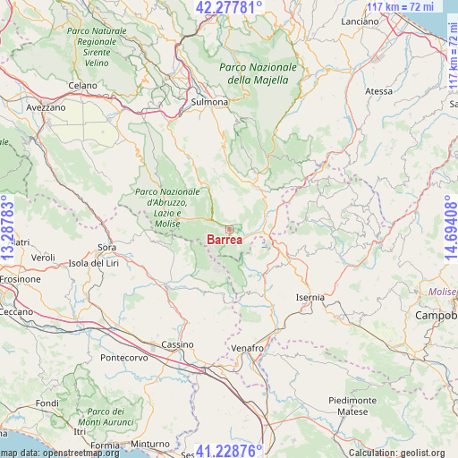
Barrea GPS coordinates[2]
41° 45' 19.548" North, 13° 59' 27.42" East
| Map corner | latitude | longitude |
|---|---|---|
| Upper-left | 42.27781°, | 13.28783° |
| Center: | 41.75543°, | 13.99095° |
| Lower-right: | 41.22876°, | 14.69408° |
| Map W x H: | 116.6×116.6 km | = 72.5×72.5mi |
| max Lat: | 47.04031° ⇑72.3% North |
| Barrea: | 41.75543° |
| min Lat: | ⇓27.7% South 35.50142° |
| min Long | Barrea | max Long |
| 6.69888° | 13.99095° | 18.48682° |
| W 78.2%⇐ | ⇒21.8% E |
Elevation
Elevation of Barrea is 1016 m = 3333 ft, and this is 709.3 m = 2327 ft above average elevation for this country.
| Max E: |
2085 m = 6841 ft | 2.8% |
| Barrea | 1016 m 3333 ft | |
| Avg. | 306.7 m = 1006 ft | |
Min E: |
-4 m = -13 ft | 97.2% |
See also: Italy elevation on elevation.city.
Geographical zone
Barrea is located in North temperate zone (between Tropic of Cancer and the Arctic Circle). Distance of this Northern Tropic circle is 2036.8 km =1265.6 mi to South.| Distance of | km | miles | from Barrea |
|---|---|---|---|
| North Pole | 5364.3 | 3333.2 | to North |
| Arctic Circle | 2758.4 | 1714 | to North |
| Tropic Cancer | 2036.8 | 1265.6 | to South |
| Equator | 4642.8 | 2884.9 | to South |


Nearby cities:
15 places around Barrea: (largest is in red/bold)
• Alfedena
4.3 km =2.7 mi,  121°
121°
• Castel San Vincenzo
12.6 km =7.8 mi,  152°
152°
• Castel di Sangro
10.1 km =6.3 mi,  71°
71°
• Cerro al Volturno
14.6 km =9.1 mi,  140°
140°
• Civitella Alfedena
4.1 km =2.5 mi,  285°
285°
• Montenero Val Cocchiara
7.8 km =4.8 mi, 123°
• Opi
13.6 km =8.5 mi,  280°
280°
• Pizzone
9.9 km =6.2 mi,  157°
157°
• Rionero Sannitico
13.2 km =8.2 mi,  111°
111°
• Rivisondoli
14.2 km =8.8 mi,  26°
26°
• Roccaraso
12.7 km =7.9 mi, 34°
• San Donato Val di Comino
15.8 km =9.8 mi,  250°
250°
• Scontrone
4.1 km =2.5 mi,  103°
103°
• Settefrati
15 km =9.3 mi,  230°
230°
• Villetta Barrea
4.9 km =3 mi,  298°
298°
Sources, notices
• [Note1] Compared only with cities in Italy existing in our database
• [Src1] Map data: © OpenStreetMap contributors (CC-BY-SA)
• [Src2] Other city data from geonames.org with taken over terms of usage.
• [Src3] Geographical zone / Annual Mean Temperature by Robert A. Rohde @ Wikipedia
