Opi geodata
Opi (Abruzzo) is a seat of a third-order administrative division; located in Italy in Europe/Rome (GMT+2) time zone. With population of 293 people, there are 10701 cities with bigger population in this country. Compared to other cities in Italy, 72.2% of cities are located further ↑North; 76.9% of cities are located further ←West and 98.4% of cities have lower elevation than Opi. Note1


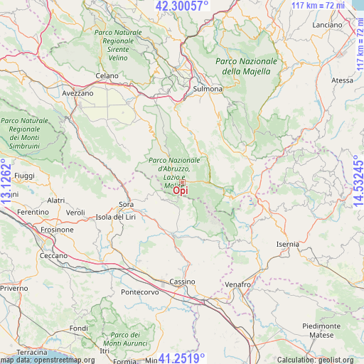
Opi GPS coordinates[2]
41° 46' 42.168" North, 13° 49' 45.552" East
| Map corner | latitude | longitude |
|---|---|---|
| Upper-left | 42.30057°, | 13.1262° |
| Center: | 41.77838°, | 13.82932° |
| Lower-right: | 41.2519°, | 14.53245° |
| Map W x H: | 116.6×116.6 km | = 72.5×72.5mi |
| max Lat: | 47.04031° ⇑72.2% North |
| Opi: | 41.77838° |
| min Lat: | ⇓27.8% South 35.50142° |
| min Long | Opi | max Long |
| 6.69888° | 13.82932° | 18.48682° |
| W 76.9%⇐ | ⇒23.1% E |
Elevation
Elevation of Opi is 1154 m = 3786 ft, and this is 847.3 m = 2780 ft above average elevation for this country.
| Max E: |
2085 m = 6841 ft | 1.6% |
| Opi | 1154 m 3786 ft | |
| Avg. | 306.7 m = 1006 ft | |
Min E: |
-4 m = -13 ft | 98.4% |
See also: Italy elevation on elevation.city.
Geographical zone
Opi is located in North temperate zone (between Tropic of Cancer and the Arctic Circle). Distance of this Northern Tropic circle is 2039.4 km =1267.2 mi to South.| Distance of | km | miles | from Opi |
|---|---|---|---|
| North Pole | 5361.7 | 3331.6 | to North |
| Arctic Circle | 2755.9 | 1712.4 | to North |
| Tropic Cancer | 2039.4 | 1267.2 | to South |
| Equator | 4645.3 | 2886.5 | to South |


Nearby cities:
15 places around Opi: (largest is in red/bold)
• Alvito
11.9 km =7.4 mi,  214°
214°
• Barrea
13.6 km =8.5 mi,  100°
100°
• Bisegna
16.9 km =10.5 mi,  339°
339°
• Campoli Appennino
13 km =8.1 mi,  248°
248°
• Civitella Alfedena
9.5 km =5.9 mi, 98°
• Gallinaro
14 km =8.7 mi,  190°
190°
• Pescasseroli
4.5 km =2.8 mi,  308°
308°
• Pescosolido
14.7 km =9.1 mi,  256°
256°
• Picinisco
15.1 km =9.4 mi,  167°
167°
• Posta Fibreno
15.7 km =9.8 mi,  232°
232°
• San Donato Val di Comino
8 km =5 mi, 190°
• Scanno
14.6 km =9.1 mi,  16°
16°
• Settefrati
12.1 km =7.5 mi, 171°
• Vicalvi
15 km =9.3 mi,  222°
222°
• Villetta Barrea
9.1 km =5.7 mi,  91°
91°
Sources, notices
• [Note1] Compared only with cities in Italy existing in our database
• [Src1] Map data: © OpenStreetMap contributors (CC-BY-SA)
• [Src2] Other city data from geonames.org with taken over terms of usage.
• [Src3] Geographical zone / Annual Mean Temperature by Robert A. Rohde @ Wikipedia
