Roccaraso geodata
Roccaraso (Abruzzo) is a seat of a third-order administrative division; located in Italy in Europe/Rome (GMT+2) time zone. With population of 1,218 people, there are 5899 cities with bigger population in this country. Compared to other cities in Italy, 71.6% of cities are located further ↑North; 78.8% of cities are located further ←West and 98.9% of cities have lower elevation than Roccaraso. Note1


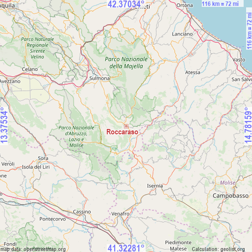
Roccaraso GPS coordinates[2]
41° 50' 55.392" North, 14° 4' 42.456" East
| Map corner | latitude | longitude |
|---|---|---|
| Upper-left | 42.37034°, | 13.37534° |
| Center: | 41.84872°, | 14.07846° |
| Lower-right: | 41.32281°, | 14.78159° |
| Map W x H: | 116.5×116.5 km | = 72.4×72.4mi |
| max Lat: | 47.04031° ⇑71.6% North |
| Roccaraso: | 41.84872° |
| min Lat: | ⇓28.4% South 35.50142° |
| min Long | Roccaraso | max Long |
| 6.69888° | 14.07846° | 18.48682° |
| W 78.8%⇐ | ⇒21.2% E |
Elevation
Elevation of Roccaraso is 1248 m = 4094 ft, and this is 941.3 m = 3088 ft above average elevation for this country.
| Max E: |
2085 m = 6841 ft | 1.1% |
| Roccaraso | 1248 m 4094 ft | |
| Avg. | 306.7 m = 1006 ft | |
Min E: |
-4 m = -13 ft | 98.9% |
See also: Italy elevation on elevation.city.
Geographical zone
Roccaraso is located in North temperate zone (between Tropic of Cancer and the Arctic Circle). Distance of this Northern Tropic circle is 2047.2 km =1272.1 mi to South.| Distance of | km | miles | from Roccaraso |
|---|---|---|---|
| North Pole | 5353.9 | 3326.8 | to North |
| Arctic Circle | 2748 | 1707.5 | to North |
| Tropic Cancer | 2047.2 | 1272.1 | to South |
| Equator | 4653.1 | 2891.3 | to South |


Nearby cities:
15 places around Roccaraso: (largest is in red/bold)
• Alfedena
13.1 km =8.1 mi,  195°
195°
• Ateleta
9.9 km =6.2 mi,  86°
86°
• Barrea
12.7 km =7.9 mi,  214°
214°
• Castel del Giudice
12.7 km =7.9 mi, 86°
• Castel di Sangro
7.6 km =4.7 mi,  162°
162°
• Civitella Alfedena
14.6 km =9.1 mi,  230°
230°
• Gamberale
12.5 km =7.8 mi,  59°
59°
• Montenero Val Cocchiara
14.7 km =9.1 mi,  182°
182°
• Pescocostanzo
4.4 km =2.7 mi,  346°
346°
• Rivisondoli
2.6 km =1.6 mi,  337°
337°
• Rocca Pia
12.7 km =7.9 mi,  318°
318°
• San Pietro Avellana
10.9 km =6.8 mi,  127°
127°
• Sant'Angelo del Pesco
15 km =9.3 mi,  75°
75°
• Scontrone
11.8 km =7.3 mi, 196°
• Villetta Barrea
14.1 km =8.8 mi,  235°
235°
Sources, notices
• [Note1] Compared only with cities in Italy existing in our database
• [Src1] Map data: © OpenStreetMap contributors (CC-BY-SA)
• [Src2] Other city data from geonames.org with taken over terms of usage.
• [Src3] Geographical zone / Annual Mean Temperature by Robert A. Rohde @ Wikipedia
