Arpaia geodata
Arpaia (Campania) is a seat of a third-order administrative division; located in Italy in Europe/Rome (GMT+2) time zone. With population of 1,886 people, there are 4344 cities with bigger population in this country. Compared to other cities in Italy, 78.2% of cities are located further ↑North; 83.2% of cities are located further ←West and 61.1% of cities have lower elevation than Arpaia. Note1


Arpaia GPS coordinates[2]
41° 2' 12.408" North, 14° 33' 6.3" East
| Map corner | latitude | longitude |
|---|---|---|
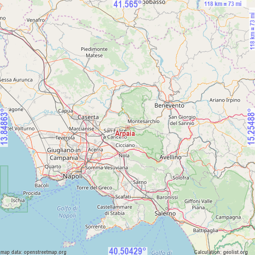
| Upper-left | 41.565°, | 13.84863° |
| Center: | 41.03678°, | 14.55175° |
| Lower-right: | 40.50429°, | 15.25488° |
| Map W x H: | 117.9×117.9 km | = 73.3×73.3mi |
| max Lat: | 47.04031° ⇑78.2% North |
| Arpaia: | 41.03678° |
| min Lat: | ⇓21.8% South 35.50142° |
| min Long | Arpaia | max Long |
| 6.69888° | 14.55175° | 18.48682° |
| W 83.2%⇐ | ⇒16.8% E |
Elevation
Elevation of Arpaia is 307 m = 1007 ft, and this is 0.30000000000001 m = 1 ft above average elevation for this country.
| Max E: |
2085 m = 6841 ft | 38.9% |
| Arpaia | 307 m 1007 ft | |
| Avg. | 306.7 m = 1006 ft | |
Min E: |
-4 m = -13 ft | 61.1% |
See also: Italy elevation on elevation.city.
Geographical zone
Arpaia is located in North temperate zone (between Tropic of Cancer and the Arctic Circle). Distance of this Northern Tropic circle is 1956.9 km =1216 mi to South.| Distance of | km | miles | from Arpaia |
|---|---|---|---|
| North Pole | 5444.2 | 3382.9 | to North |
| Arctic Circle | 2838.3 | 1763.6 | to North |
| Tropic Cancer | 1956.9 | 1216 | to South |
| Equator | 4562.9 | 2835.3 | to South |


Nearby cities:
15 places around Arpaia: (largest is in red/bold)
• Airola
2.5 km =1.6 mi,  14°
14°
• Arienzo
4.7 km =2.9 mi,  256°
256°
• Bonea
6.8 km =4.2 mi,  53°
53°
• Bucciano
4.8 km =3 mi,  17°
17°
• Cervinara
5.6 km =3.5 mi,  109°
109°
• Forchia
1.5 km =0.9 mi,  246°
246°
• Luzzano
3.7 km =2.3 mi,  339°
339°
• Moiano
4.8 km =3 mi,  352°
352°
• Paolisi
2.3 km =1.4 mi,  88°
88°
• Roccarainola
7.2 km =4.5 mi,  185°
185°
• Rotondi
3.7 km =2.3 mi,  96°
96°
• San Felice A Cancello
5.8 km =3.6 mi, 247°
• Sant'Agata de'Goti
7.4 km =4.6 mi,  322°
322°
• Santa Maria A Vico
7.4 km =4.6 mi, 260°
• Trescine
6 km =3.7 mi, 105°
Sources, notices
• [Note1] Compared only with cities in Italy existing in our database
• [Src1] Map data: © OpenStreetMap contributors (CC-BY-SA)
• [Src2] Other city data from geonames.org with taken over terms of usage.
• [Src3] Geographical zone / Annual Mean Temperature by Robert A. Rohde @ Wikipedia
