Airola geodata
Airola (Campania) is a seat of a third-order administrative division; located in Italy in Europe/Rome (GMT+2) time zone. With population of 7,305 people, there are 1334 cities with bigger population in this country. Compared to other cities in Italy, 77.9% of cities are located further ↑North; 83.3% of cities are located further ←West and 54.4% of cities have lower elevation than Airola. Note1


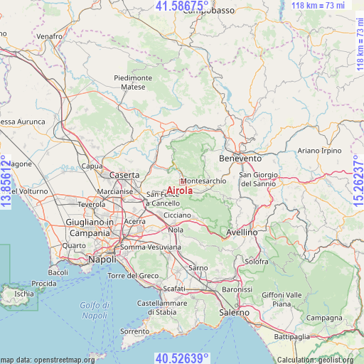
Airola GPS coordinates[2]
41° 3' 31.356" North, 14° 33' 33.264" East
| Map corner | latitude | longitude |
|---|---|---|
| Upper-left | 41.58675°, | 13.85612° |
| Center: | 41.05871°, | 14.55924° |
| Lower-right: | 40.52639°, | 15.26237° |
| Map W x H: | 117.9×117.9 km | = 73.3×73.3mi |
| max Lat: | 47.04031° ⇑77.9% North |
| Airola: | 41.05871° |
| min Lat: | ⇓22.1% South 35.50142° |
| min Long | Airola | max Long |
| 6.69888° | 14.55924° | 18.48682° |
| W 83.3%⇐ | ⇒16.7% E |
Elevation
Elevation of Airola is 262 m = 860 ft, and this is 44.7 m = 147 ft below average elevation for this country.
| Max E: |
2085 m = 6841 ft | 45.6% |
| Avg. | 306.7 m = 1006 ft | |
| Airola | 262 m = 860 ft | |
Min E: |
-4 m = -13 ft | 54.4% |
See also: Italy elevation on elevation.city.
Geographical zone
Airola is located in North temperate zone (between Tropic of Cancer and the Arctic Circle). Distance of this Northern Tropic circle is 1959.4 km =1217.5 mi to South.| Distance of | km | miles | from Airola |
|---|---|---|---|
| North Pole | 5441.8 | 3381.4 | to North |
| Arctic Circle | 2835.9 | 1762.1 | to North |
| Tropic Cancer | 1959.4 | 1217.5 | to South |
| Equator | 4565.3 | 2836.7 | to South |


Nearby cities:
15 places around Airola: (largest is in red/bold)
• Arienzo
6.2 km =3.9 mi,  235°
235°
• Arpaia
2.5 km =1.6 mi,  194°
194°
• Bonea
5.1 km =3.2 mi,  71°
71°
• Bucciano
2.2 km =1.4 mi,  21°
21°
• Cervinara
6.3 km =3.9 mi,  132°
132°
• Cirignano
7 km =4.3 mi, 69°
• Forchia
3.6 km =2.2 mi,  213°
213°
• Luzzano
2.2 km =1.4 mi,  298°
298°
• Moiano
2.6 km =1.6 mi,  331°
331°
• Montesarchio
6.9 km =4.3 mi,  86°
86°
• Paolisi
2.9 km =1.8 mi,  144°
144°
• Rotondi
4.2 km =2.6 mi, 133°
• San Felice A Cancello
7.6 km =4.7 mi,  232°
232°
• Sant'Agata de'Goti
6.2 km =3.9 mi, 303°
• Trescine
6.5 km =4 mi, 128°
Sources, notices
• [Note1] Compared only with cities in Italy existing in our database
• [Src1] Map data: © OpenStreetMap contributors (CC-BY-SA)
• [Src2] Other city data from geonames.org with taken over terms of usage.
• [Src3] Geographical zone / Annual Mean Temperature by Robert A. Rohde @ Wikipedia
