San Felice A Cancello geodata
San Felice A Cancello (Campania) is a seat of a third-order administrative division; located in Italy in Europe/Rome (GMT+2) time zone. With population of 16,571 people, there are 545 cities with bigger population in this country. Compared to other cities in Italy, 78.5% of cities are located further ↑North; 82.5% of cities are located further ←West and 71.6% of cities have higher elevation than San Felice A Cancello. Note1
Administrative division(s):
- Level 1: Campania
- Level 2: Provincia di Caserta
- Level 3: San Felice a Cancello
Current local time in San Felice A Cancello:
08:00 PM, WednesdayDifference from your time zone: hours


San Felice A Cancello GPS coordinates[2]
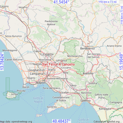
41° 1' 1.272" North, 14° 29' 14.496" East
| Map corner | latitude | longitude |
|---|---|---|
| Upper-left | 41.5454°, | 13.78424° |
| Center: | 41.01702°, | 14.48736° |
| Lower-right: | 40.48437°, | 15.19049° |
| Map W x H: | 118×118 km | = 73.3×73.3mi |
| max Lat: | 47.04031° ⇑78.5% North |
| San Felice A Cancello: | 41.01702° |
| min Lat: | ⇓21.5% South 35.50142° |
| min Long | San Felice A Ca | max Long |
| 6.69888° | 14.48736° | 18.48682° |
| W 82.5%⇐ | ⇒17.5% E |
Elevation
Elevation of San Felice A Cancello is 89 m = 292 ft, and this is 217.7 m = 714 ft below average elevation for this country.
| Max E: |
2085 m = 6841 ft | 71.6% |
| Avg. | 306.7 m = 1006 ft | |
| San Felice A Cancello | 89 m = 292 ft | |
Min E: |
-4 m = -13 ft | 28.4% |
See also: Italy elevation on elevation.city.
Geographical zone
San Felice A Cancello is located in North temperate zone (between Tropic of Cancer and the Arctic Circle). Distance of this Northern Tropic circle is 1954.7 km =1214.6 mi to South.| Distance of | km | miles | from San Felice A Cancello |
|---|---|---|---|
| North Pole | 5446.4 | 3384.2 | to North |
| Arctic Circle | 2840.5 | 1765 | to North |
| Tropic Cancer | 1954.7 | 1214.6 | to South |
| Equator | 4560.7 | 2833.9 | to South |


Nearby cities:
15 places around San Felice A Cancello: (largest is in red/bold)
• Airola
7.6 km =4.7 mi,  52°
52°
• Arienzo
1.4 km =0.9 mi,  37°
37°
• Arpaia
5.8 km =3.6 mi,  67°
67°
• Camposano
8 km =5 mi,  153°
153°
• Cervino
5.9 km =3.7 mi,  295°
295°
• Cicciano
7.1 km =4.4 mi, 145°
• Durazzano
6 km =3.7 mi,  328°
328°
• Forchia
4.4 km =2.7 mi, 68°
• Luzzano
7 km =4.3 mi, 35°
• Montedecoro
6 km =3.7 mi,  281°
281°
• Paolisi
8 km =5 mi, 73°
• Pezzalunga
6 km =3.7 mi,  225°
225°
• Roccarainola
6.8 km =4.2 mi,  136°
136°
• Sant'Agata de'Goti
8.1 km =5 mi,  5°
5°
• Santa Maria A Vico
2.1 km =1.3 mi, 298°
Sources, notices
• [Note1] Compared only with cities in Italy existing in our database
• [Src1] Map data: © OpenStreetMap contributors (CC-BY-SA)
• [Src2] Other city data from geonames.org with taken over terms of usage.
• [Src3] Geographical zone / Annual Mean Temperature by Robert A. Rohde @ Wikipedia
